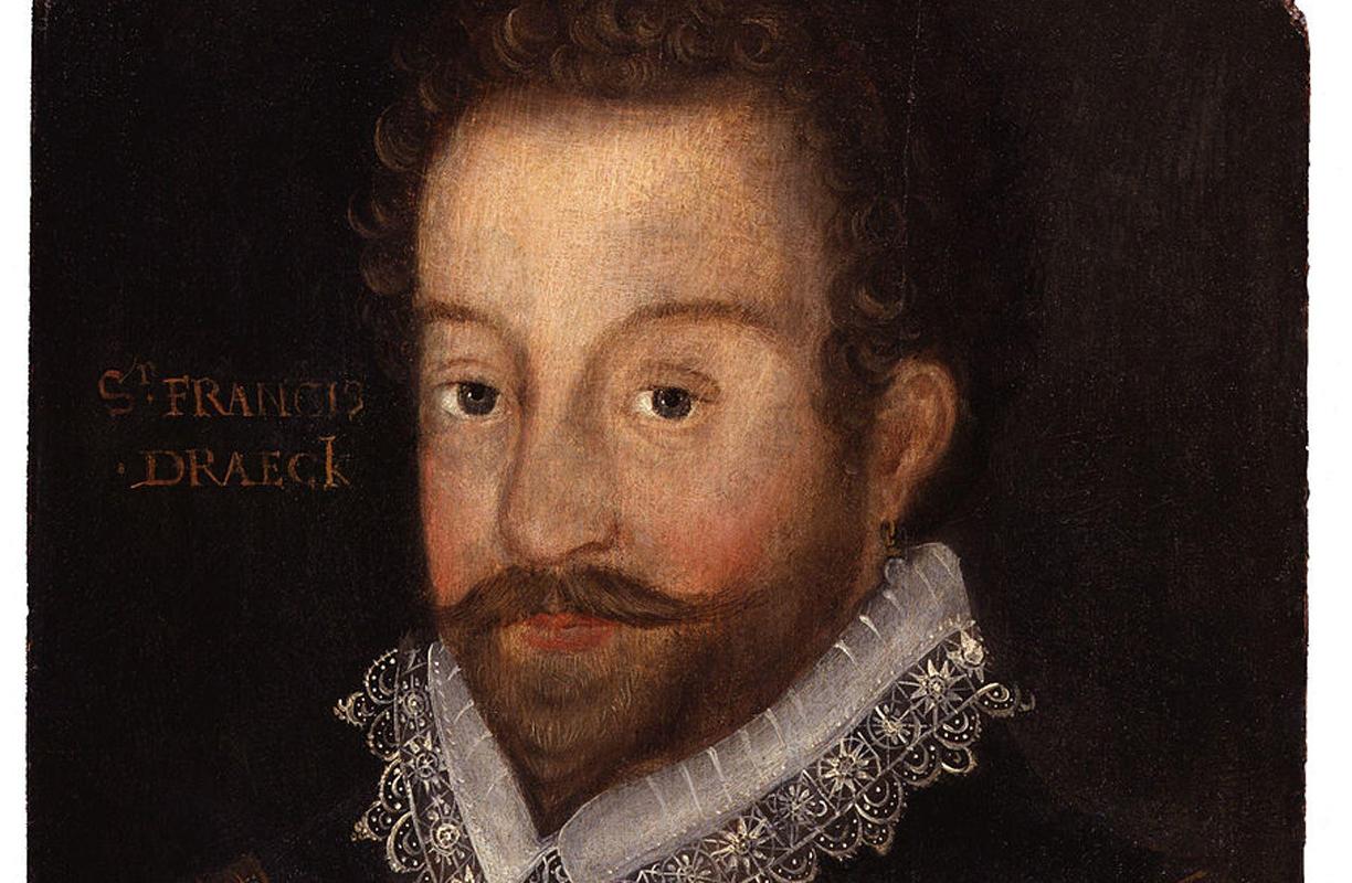
Category Archives: HISTORY/HISTORIA

HISTORY / HISTORIA
The history of the Colonial Zone and Dominican Republic.

Category – Basic History

Category – Historical Documents

EDOUARD MONTULE VOYAGE 1817. A voyage to North America, and the West Indies in 1817

HISTORICAL MAPS. Old Antique Maps of Colonial Zone

JAMES LOGAN JOURNEY 1838. Notes of a journey through Canada, USA, and the West Indies.

People in History

Anacaona

Diego Colón (Columbus) 1480 – 1526

Eugenio María de Hostos

Francisco de Bobadilla

Francisco del Rosario Sánchez

Juan Pablo Duarte

Father Bartolomé de Las Casas

Fray Anton de Montesinos

Frey Nicolás Ovando

Las Hermanas Mirables / The Mirabal Sisters (The Hermanas Mirabal Museum, Home, Park and Monuments)

Luisa Ozema Pellerano de Castro

María de Toledo

Maria Trinidad Sanchez

Sir Francis Drake (Pirate Drake, Privater Drake)

Pedro Santana

Marcelo de Villalobos

Rafael Leonidas Trujillo Molina

Sir Francis Drake

Sir Francis Drake

Sir Francis Drake, Pirate Drake also known as Privateer Drake (1541-1596) was known for many things. Spain called him a pirate and England called him a sailor and privateer.

History | Slave Trade | The Commission | Santo Domingo Invasion | Voyage Maps | Drake Settles Down | Interesting Facts

History

Francis Drake was born in Tavistock, Devon, England in either 1541 or 1542. He was the son of Edmund Drake, a farmer later turned preacher.

The Drake family fled to Kent during the Roman Catholic uprising of 1549. When Francis, the second son in a large family, was 13 he went to sea on a cargo barge. By the time he was 20 he became master of the ship.

When the captain of the ship died Drake assumed command making his first sail to the new world when he was 23. He was involved in some of the first English slave trade expeditions. Loved by Queen Elizabeth 1, Drake went on to become one of the most famous men in Elizabethan times. As a sailor, adventurer, navigator, politician, engineer and landowner, he was a legend in his own lifetime.

Slave Trade

Sir John Hawkins, a cousin of Drake, was given permission from Queen Elizabeth to make his first voyage in 1562. Drake accompanied him on this voyage. Hawkins was to bring Africans to the Americas under their own free will. He agreed to this condition but did not do as he said. He captured the Africans, promising them free land and riches in the new world. Then he sold most of the slaves in what is now known as the Dominican Republic. Then Hawkins returned home with a large profit and ships laden with ivory, hides, and sugar. Thus began the British slave trade.

When the ship Hawkins manned returned to England Queen Elizabeth was horrified. She said that what he did was detestable and it would call down vengeance from heaven upon all who took part. But, after she saw the money that could be made, she joined in a partnership with Hawkins and even gave him his a new ship called Jesus of Lubeck, also known as The Good Ship Jesus.

It is very ironic that Drakes’ cousin and Drake himself were considered to be very religious men. Hawkins required his crew to serve God and to love one another. Drake held services on board his ship twice a day.

I cannot understand this, it was OK for him to lie, cheat and steal. Taking the African people by their lies and false promises. Stealing the belongings of others. And they still considered themselves to be religious.

The Commission

In 1577 Queen Elizabeth I commissioned three men to sail around the world. On November 15, 1577. The Queen’s Corsair consisting of the captains Sir Francis Drake (whom she called lovingly, “my dear pirate”), John Winter, and Thomas Doughty set sail on their voyages.

In time Drake became the leader of the group. He was to attack all Spanish settlements. Drake sailed to America with 40 ships and more than 2,000 soldiers. He attacked the Spanish ports throughout the Caribbean.

Drake sailed his ship “The Golden Hind” on December 13, 1577. Francis Drake became the second man to sail around the world and the first Englishman to accomplish this feat on September 26, 1580.

Upon Drakes return to England he presented the queen a very large bounty. Now she really loved her “dear pirate”.

On April 4, 1581 he was knighted by Queen Elizabeth on the deck of the Golden Hind. This act gave Francis Drake a title. He became Sir Francis Drake, mayor of Plymouth and a Parliament member. The Queen also presented him with a special sword. Because of all the attention she paid to Drake others followed in his footsteps and became privateers also.

Francis Drake hated the Spaniards and their Catholic religion, probably having to do with his families flight from their home when he was young. He devoted his life to fighting against the Spanish and all they controlled. They called him a pirate but England called him a sailor and privateer.

Drake at age of 43

Drake at age of 43, with the coat of arms conferred on him on April 4, 1581, after he was knighted at Deptford, on the deck of the Golden Hind, the first English ship to go around the world. To see a larger view of this picture and to read “Sir Francis Drake : A Pictorial Biography with an Historical Introduction by Lt. Commander David W. Waters & Richard Boulind and a Detailed Catalogue of the Author’s Collection” in the rare book section of the US Library of Congress.

Invasion

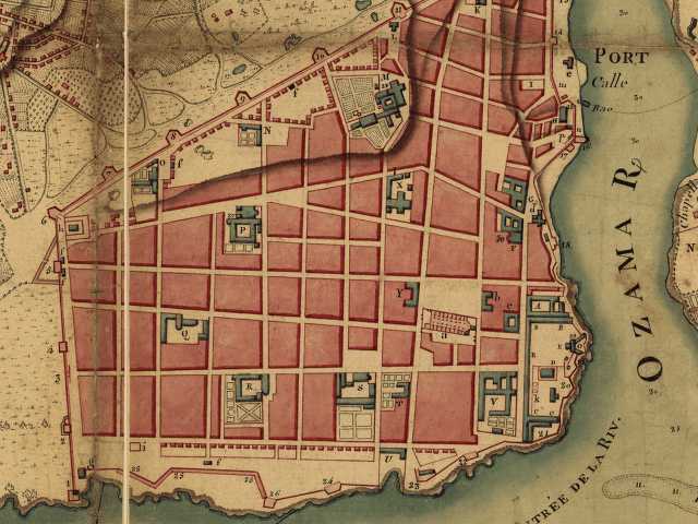
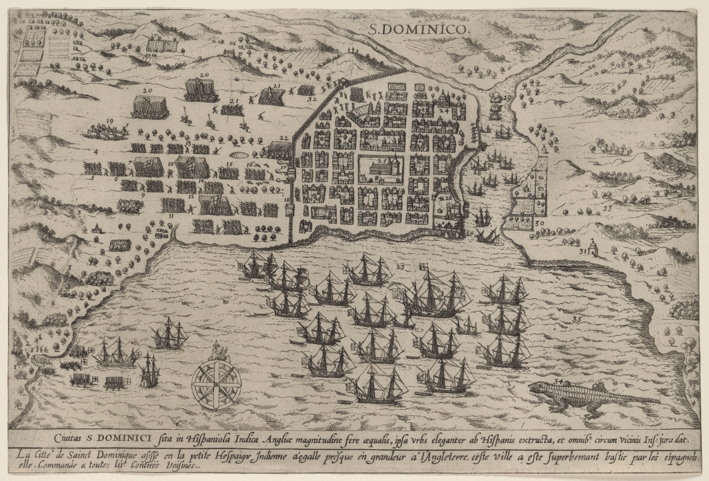
January 1586 Sir Francis Drake landed at the Spanish colony of Santo Domingo bringing the entire city to its knees. His invasion and demolition weakened the Spanish dominion over the island.

For more than 50 years everything in the colony was abandoned and left to the mercy of the pirates. Drake drove the Spanish garrison out of Santo Domingo. He burned the city methodically, piece by piece until he received a ransom of 30,000 crowns. The amount he wanted was much more but he settled on this ransom. It is also told that the people of Santo Domingo gave him all their treasures. After much persuasion by the towns people, and when there was nothing else to take, Drake left the ruined city.

The church Santa María, the first church in the new world, was ransacked and burnt. Treasures were stolen and records burnt. The graveyard behind the chapel and its records were destroyed also. This left no records of the people who were interred there. The San Francisco Monastery was also significantly damaged in Drakes 1568 invasion on the city.

After Drakes invasion on Santo Domingo, he moved on to Cartagena (now known as Columbia) and St. Augustine (in Florida, USA). The war between England and Spain started because of these terrible acts of piracy.

Voyage Maps

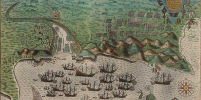
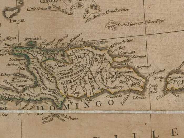
Drake sailed directly west from Santiago in the Cape Verde Islands off the coast of West Africa. The first port Drake reached in the West Indies was Santo Domingo in Hispaniola, present-day Haiti and Dominican Republic. This image shows the English fleet in the bay, and the infantry battalions attacking the town. This map represents the first printed view of this locality.

To see this map and more about the Caribbean Raid. Many interesting PDF maps of Sir Francis Drakes early voyages.

Drakes Settles Down

Sir Francis Drake returned to England, got married and lived on a large estate outside of London. On January 28, 1596, he died aboard his ship the Defiance. He was struck by a tropical disease that he probably picked up during his last trip to the Americas. He died and was buried at sea. It was said that he got out of his deathbed early the morning of his death and tried to put on his suit of armor. He wanted to die as a soldier.

Sir Francis Drake died of dysentery when he was about 55. He was buried at sea in a lead coffin off Puerto Bello to the sound of trumpets and cannons.

Sir Francis Drake by Jodocus Hondius

Interesting Facts

*There were many different types and classes of what we clump together as pirates now.
– Pirate is a robber and destroyer of ships at sea.
– Buccaneer was originally an inhabitant of Hispaniola. The name coming from a Taino word boucan or barbecue. Because these people were said to prepare their meat in this manner they were originally called boucaniers.
– Privateer was a privately owned ship and crew hired by a national government during wartime to plunder the ships of an enemy nation.
– Corsair was a Mediterranean pirate of the 16th century.

A Map titled S Dominico M.D.LXXXV (privilege dated December 20, 1584)

*The Golden Age of Piracy came about soon after the discovery of the New World and continued for about 250 years.

*When the Pope divided the New World between Spain and Portugal in 1494 the other European nations were not very happy. They wanted some of the stolen Aztec gold also. War was a given.

*The New World coast from South America through the Caribbean to Northern Florida was known as “The Spanish Main”.

*In 1630 a treaty was signed with Spain enabling the English and French to colonize some of the lands along the Spanish Main.

*One of the main sources of food the settlers consumed on the island of Hispaniola was the wild pigs originally introduced by the Spanish. The pigs were barbecued on open fires called buccans or boucan. This is how the settlers got the title buccaneers.

*The Spanish were getting a little nervous because of all the buccaneers on Hispaniola. They sent hunters to kill all the pigs which in turn made the buccaneers turn to piracy because their food source was gone. Later Spain realized they made a dire mistake.

*Many of the buccaneers (they called themselves Brethren of the Coast) moved on to a new island named Tortuga/ Turtle. It is located off the coast on the Haitian side of the island. This island became a sanctuary for the Buccaneers because of its perfect habitat and location.

*Not all pirates were fierce outlaws. Many were just sailors trying to make a living the only way they were able.

*Many things about how the ship would be run was agreed upon by all before the ship left port. They decided where to sail, how the bounty would be divided (usually the most going to the captain, then the skilled labor on the ship and the least amounts going to the laborers), and who would be captain.

*Sir Francis Drake introduced pipe smoking to Elizabethan age of England.

*Drake named Virginia in United States after Queen Elizabeth, the Virgin Queen

Other famous pirates I found that visited the Santo Domingo colony included
*Blackbeard – (Edward Thatch or Teach) Samana Bay in Hispaniola (Dominican Republic) in 1718?
*William Kidd, also known as The Unlucky Pirate.
*Sir Henry Morgan, also known as The Pirate King (1654 in Hispaniola)

For more information on Sir Francis Drake check out these web sites –
Golden Hind | The Un Museum.org | Library of Congress – Exhibitions


Basic History Of Dominican Republic

General History Of Dominican Republic Condensed

The Dominican Republic is an island in the Caribbean that has a rich and unique history starting with the Indigenous Taino People, The Spanish Conquest, Haitian Rule to the present time.

1.Before Written History | 2.Arrival of the Foreigners | 3.More Recent History | 4.And Now Ciudad Colonial… | 5.”List of the Firsts” | 6.Cultural Treasures

Before Written History

Taino cave drawings
Taino cave drawings

Before the Europeans arrived on the island of Hispaniola and claimed they were the so-called “discoverers” of the entire island, it was occupied by the Taino Indians.

The Tainos lived on the island they lovingly called Quisqueya. In the Taino language this means “Land for which there is none better”.

The peaceful Tainos (they did war with neighboring tribes such as the bloodthirsty Caribs) almost entire demise coincided with the arrival of the Spaniards and their abuse of these original inhabitants of this small island. These “savages”, as the Europeans thought of them, who had ruled the island, now lost their way of life and eventually most lost their lives because of this invasion of the Whites. The Taino nation was doomed the moment Christopher Columbus invaded their beloved island.

The Arrival of the Foreigners

Replica of one of the ships Columbus arrived in.

Christopher Columbus, in Spanish Cristóbal Colón, came to the island on the ship La Santa María. There were two other ships that accompanied him, La Pinta and La Niña. He found the island for the first time on October 12, 1492.

Columbus first landed on one of the islands in the Bahamas. Later that year also found Cuba and an island he called La Isla Espanola (he was on the western side of the island).

When Columbus returned to Spain after visiting Hispanola he left some of his men behind. They were instructed to search for the gold he thought was on the island.

When Columbus made his second voyage, he returned to the island only to find the people he left on Hispaniola had vanished. All were assumed to have died.

The fleet of 17 ships continued traveling along the coast toward the east. Finally, stopping to create a fortified post, Christopher left his brother and some men on the island. They were instructed to search the interior of the island for that coveted and promised gold. Columbus left and continued his quest, searching elsewhere for the gold he promised the Queen.

By the spring of 1494, the island of Hispaniola was colonized. The island Columbus declared to be “The most beautiful island the human eyes have ever seen” is where he wanted his remains entered to rest forever.

The first Europeans settled Hispaniola in 1496.

The brother of Christopher, Bartholomew Columbus founded Santo Domingo, the capital of the Dominican Republic, officially on August 5, 1498. The city, originally named La Isabela, is the oldest European city founded by Europeans in the “New World”. It is the oldest colonial city in all of the Americas.

Santo Domingo was the place of origin for much of the exploration and conquest of the New World throughout its first century of existence. The “discovery” of Puerto Rico led by Ponce de Leon, the conquest of Mexico led by Cortez, and the first sighting of the Pacific Ocean led by Balboa, all started here in Santo Domingo.

The famous pirate Francis Drake invaded the settlement in 1568 and weakened the Spanish domain over Hispaniola. The Spaniards abandoned the city and left it to Drake and the pirates for more than 50 years. It remained this way until the French invaded the west side of the island in 1655. After many treaties and forced annexations the part of the island originally called by Santo Domingo was less than half it’s original size.

Commanded by Toussaint Louverture, the Haitians took over the island in 1822. They ruled the island for 22 years, fighting for their lost independence.

The Spaniards again became independent of Haitian rule on February 27, 1844. Thanks to their leaders Juan Pablo Duarte, Francisco del Rosario Sánchez and Ramón Matías Mella. This was when the Spanish part of the island became known as the Republica Dominicana (Dominican Republic). The Haitian’s were totally defeated in 1861 and sent to their own side of the island. The struggle to keep control of the country was ongoing, even after Spanish independence was gained.

More Recent History

Revolution 1965 Calle Isabel la Católica and Luperon, Ciudad Colonial

In 1916 The United States of America, wanting to have more power and influence in the Dominican Republic, used World War 1 as an excuse to bring in the Marines. They came to “protect” the country against the “bad” European powers.

The USA changed the infrastructure of the country to best benefit them. The Dominican Republic had its first, somewhat, free elections in 1924 which put Rafael Leonidas Trujillo in power.

The US finally decided to leave the Dominican Republic to take care of itself. Soon after Trujillo was able to gain power. In 1930 he took over completely. The Trujillo dictatorship ended on May 30, 1961 with his execution by ambush. He died one of the richest men in the world.

After this there were many political and economic problems and the country was in turmoil. The US Marines returned in 1965 to occupy the country again. This time because they said the uprising was the fault of the Communists. USA left when Dr. Joaquín Balaguer was elected president for a second time (many say the election was fixed). Through all these political struggles and civil wars the country became independent.

1992 marked the 500th anniversary, El Quinto Centenario, of Christopher Columbus’ opening of Las Americas to the colonization of the Europeans.

The Columbus Lighthouse, Faro a Colón, with an approximate cost of 400 million Dominican pesos, was erected in honor of this occasion. This massive structure is in the shape of a cross. It is claimed that the building houses the remains of Cristobal Colón. The museum also is home to many exhibits and historical items.

Faro a Colón is amazing to see by day as well as the night when it is completely lit up. The spectacular lights on the top of the building form a cross in the heavens at night (the lights are only shown on special occasions because of the electricity problems) that can be seen for long distances.

See many old pictures of Santo Domingo and Dominican Republic.

And Now Ciudad Colonial…

A panoramic view of modern day Ciudad Colonial, Santo Domingo 2013

Colonial Zone, Zona Colonial or Ciudad Colonial is the oldest city in Las Americas on the island of Hispaniola in the country of Dominican Republic. It is a small town located in the capital city Santo Domingo de Guazmán. It is bordered by Río Ozama and the Caribbean Sea. There are many historical sites that were built during the time of exploration, exploitation, and colonization of the “New World.”

Much of the original city can still be seen today. The cathedral, monastery, university and hospital are among many of the “firsts” that happened here. The 16th-century buildings, homes and churches where one can see the old world Spanish architectural styles of the period. Many of these buildings are in excellent condition and are a wonder to behold.

Colonial Zone (and the surrounding sectors including San Miguel, San Lázaro, Santa Barbara, San Anton, San Carlos, Atarazana, and Cuidad Nueva) is a wonderful mix of the past and present. The old and new intertwine to make a unique visitors experience.

Live the history. Walk our streets. Visit our Museums and Historical sights. Dine in our restaurants. Meet our people. Dance to out music. You will make lasting memories. Something you may remember for a lifetime. Here in the land of firsts in “The Americas”

The “Firsts”

The city of Santo Domingo was the seat of many historic events and many of the monuments that are here are from the first 50 years of the European Conquest of America. This is why we have the title
“The Cradle of America”.

1. First Map: drawing of the northeast coast by Christopher Columbus (1493) (old maps)
2. First European Villa in the Americas: La Isabela (1494)
3. First Religious Order: Friar of San Francisco (1494)
4. First Mass officiated in the Americas: January 6, 1494.
5. First Capital of the Americas: Santo Domingo (1496-98)
6. First Monastery: San Francisco (1502)
7. First Hospital: San Nicolás de Bari (1503)
8. First House of Contracts (1503)
9. First University: Universidad de Santo Domingo (1538)
10. First Cathedral: Nuestra Señora de la Encarnación (1541)

Cultural Treasures

Painting of all the Colonial Zone monuments

There are many cultural treasures located throughout Dominican Republic. In 2010 there was a vote by the held by the International Bureau of Capitals of Culture. The bureau helps people to notice important cultural locations throughout the world. This year they focused on the Dominican Republic. There were 27 candidates for the treasure, and most were in the Colonial Zone. They received 18,420 votes.

This is a list of the places voted for and the number of votes received. You can find information about these locations in the Colonial Zone Sights section.

1) Alcázar de Colón – 4344 votes
2) Cathedral Santa María de la Encarnación – 2560
3) Fortaleza Ozama – 2369
4) Museo de las Casas Reales – 1275
5) Jardín Botánico – 1117
6) Malecón – 1092
7) Palacio de Bellas Artes – 1024
8) Barrio Chino – 972
9) Calle Las Damas – 485
10) Palacio Nacional – 443
11) Hospital San Nicolás de Bari (ruinas) – 308
12) Panteón Nacional – 284
13) Parque de los Tres Ojos de Auga – 246
14) Altar de la Patria – 238
15) Hostal Nicolás de Ovando – 223
16) Monasterio de San Francisco (ruinas) – 208
17) Faro a Colón – 196
18) Alcantarilla Colonial – 193
19) Iglesia del Convento Dominico – 184
20) Calle El Conde – 181
21) Casa de Juan Pablo Duarte – 125
22) Reales Atarazanas – 116
23) Casa de Tostado – 66
24) Parque de la Independencia – 49
25) Ceiba de Colón – 46
26) Urna original de los restos del almirante Don Cristóbal Colón – 39
27) Palacio Consistorial – 37

Historical Maps

Old Antique Maps of Colonial Zone / Mapas Antiguos de la Zona Colonial

I have added some very old maps of the Dominican Republic when what is now Dominican Republic was named Hispaniola or was only known as Santo Domingo. It is interesting to see Colonial Zone when it was fresh and new (here is a historical document I found where the writer describes the city and island). The maps of the entire country are interesting to compare.

I hope you enjoy them as much as I did when I found them.

1.Original City of Santo Domingo | 2.Plan du siège de Santo Domingo | 3.Louis Drake Mountains Map | 4.Joseph Spear Map | 5.Sir Francis Drakes Early Voyages

Original City of Santo Domingo

Santo Domingo 1755 – Stadt St. Domingo. C. F. Fritzsch, sculp. Chedel, del. 1755

A drawing of the original city of Santo Domingo – Colonial Zone. It is interesting to note the way the buildings look at this time and to notice that many of them are still the same today.

The maps name is: Stadt St. Domingo. C. F. Fritzsch, sculp. Chedel, del. This map is thought to be created and published by Leipzig in 1755. It is a perspective map and not drawn to scale. This is a birds-eye-view of the original fort which is now the Colonial Zone.

The map is located in the Library of Congress Geography and Map Division Washington, D.C. 20540-4650 USA
The digital ID of this map is: g4954s ct000107 http://hdl.loc.gov/loc.gmd/g4954s.ct000107

Plan du siège de Santo Doming[o] par Dess[a]lines, chef des révoltes de St. Domingue, forme le 15 ventôse et levé le 8 germinal an 13.

Plan du siège de Santo Doming[o] 1805

This map was created/published in 1805. It is a relief map showing the shadows and depth perspective. It is a pen and watercolor drawing. I cropped this section out of the map to show the Colonial City. It is interesting to see the buildings and the outskirts of the city. There seems to be nothing out there.

The full version that can be found in the Library of Congress
This map is stored in the Library of Congress Geography and Map Division Washington, D.C. 20540-4650 USA
Digital ID: g4954s ct000102 http://hdl.loc.gov/loc.gmd/g4954s.ct000102

Louis Drake Mountains Map

Louis Drake Mountains Map 1752

Map Title: North America, performed under the patronage of Louis Duke of Orleans, First Prince of the Blood; by the Sieur d’Anville, greatly improved by Mr. Bolton. Engraved by R. W. Seale. For Mr. Postlethwayte’s Dictionary of trade and commerce. Gravelot, delin; Walker, sculp. Created/Published: [London] Printed for John and Paul Knapton, 1752.

It is interesting to see in this map the shape of the island and the names of the towns. if you look at the other maps of the islands each has the island shaped a little differently.

Hand colored. Relief is shown pictorially. Shows provinces, cities and towns, forts, Indian villages and tribal territory. Also shows shoals, banks, and other navigational hazards off the coast of Nova Scotia and in the Caribbean area.
Repository: Library of Congress Geography and Map Division Washington, D.C. 20540-4650 USA
Map call number: G3300 1752 .B62 Vault
The Maps Digital ID: g3300 ar001300 http://hdl.loc.gov/loc.gmd/g3300.ar001300

Joseph Spear Map

Joseph Spear map 1744

To His Royal Highness. George Augustus Frederick. Prince of Wales &c. &c. &c. This chart of the West Indies, is humbly inscribed by His Royal Highness faithful & obedient servant Joseph Smith Speer. Thos. Bowen, sculpt. Speer, Joseph Smith. Created/Published: Westminster, 1774.

It is interesting to see the names of the towns at that time. Also, Dominican Republic seems to have been known as Santo Domingo.

Relief shown pictorially. Depths are shown by soundings. Shows southern United States, Mexico, Central America, West Indies, Bermudas, and northern South America. Includes acknowledgment dated Jan. 25, 1774 at Plantation Office, Whitehall by John Pownall, secry.
Repository: Library of Congress Geography and Map Division Washington, D.C. 20540-4650 USA
Map call number: G4390 1774 .S62 Vault Oversize
Maps digital ID: g4390 ar169900 http://hdl.loc.gov/loc.gmd/g4390.ar169900

Sir Francis Drakes Early Voyages

Privateer Drake visited many parts of the island of Hispaniola and also other parts of the West Indies (as the area was called at that time).

Sir Francis Drake PDF Map (opens in a new window). Click on the maps to enlarge.

More information on Sir Francis Drake