


Home | Dining & Night Life | Hotel | Sights | Pictures | Music | Colonial Zone Map | Hot Spots! Directory | Site Search

MENU
IN COLONIAL ZONE
THINGS DOMINICAN
If you found my web site useful please consider making a donation through Pay Pal . Thanks!

Our complete exchange rate tool.
Gracias a coinmill.com
|
|

site map Copyright © 2005 - 2014 All Rights Reserved. Colonial Zone-Dominican Republic (DR)
Home | Calendar | Night Life/Dining | Sight Seeing | Pictures | Businesses | Artists | Food | Helps | History | Language | Music | Media | Pastimes | Products | Tradition/Legend | Links | About Us | Buy Mamajuana | News Blog | DR Gringa's Life Blog | Dominican Dog Blog | Web Designer

Custom Search
El Fuerte de Santa Bárbara / Fort of Santa Barbara
The north section of the city did not have walls up until 1686 so building this fort was an important step in the fortification of the city. This fort was the third stage of protection in the city. Construction was started in the early 1540's. It was built in 3 different phases with the final one ending in the early 1700's. The final phase is said to have been designed by an Italian builder and a Spanish stone cutter and build with the man power of slaves.It is the only fort with a church inside.
The end of the 17th century brought constant attacks to the all the Antilles Islands. This fort was a bunker facing the mouth of the river Ozama thus giving it an excellent view of the entry port. Inside the Fort of Santa Barbara is the Iglesia de Santa Bárbara / Church of Santa Barbara
Directions: Av. Mella, between Calle Isabel la Católica and Calle Arzobispo Meriño (both of these streets lead to this monument), Zona Colonial see the map (number 25)
See all the pictures of the Fort and Church of Santa Barbara
El Fuerte de Santa Bárbara / Fort of Santa Barbara | Fuerta de la Concepcion | Casa de los Dávila/ House of Dávila | Residencia de Ovando/ Governor Nicolás Ovando's Residence | Fuerte de San Gil/ Fort of San Gil | Casa de los Medallones/ House of Medaillions or Casa de la Moneda/ House of Currencies | Casa Diego Caballero | Casa del Cordón/ House of Cords |
Fuerte de la Concepcion
Built later in the history of the colonial city, this fort is located along the farthest northwestern wall of the walled city of Santo Domingo. It was designed by Juan Bautista Ruggero in 1672 and inaugurated at its completion on February 27,1844. The strategic location was for the initial protection of the fort and helped deter many attempted take overs of the capital. It was the only fort to look towards the very isolated areas of San Carlos. This was a very strategic location because they were able to view problems coming from inside the island where as most of the forts looked towards the sea or river areas.
Included in the Fuerte de la Concepcion, which can still be seen to this day, was an approach ramp, the round watch towers, a walk around the wall and a ramp for the cannons. Gone are the ammunition storage and troop houses. It was completely destroyed in a fire in 1904 and has been completely and beautifully restored.
The gate located in this wall is named Puerta de Lemba after a slave that was executed here.
Fuerte de la Concepcion was where the people gathered when a natural disaster struck.
Directions: Palo Hicado near Independencia Park. see the map (number 3)
Casa de los Dávila/ House of Dávila
This house was the residence of don Francisco Dávila. It was one of the most modern and complete houses of its time. It had a private chapel, Capilla de los Remedios and a bunker built into the wall, Fuerte El Invencible. There is also a tower for a perfect view of the port. The house was integrated into the Casa de Ovando/ House of Ovando where the Hotel Nicolás de Ovando is now.
Directions: Calle Las Damas # 57, Colonial Zone see the map (number 78)

+click to enlarge
fort Santa Barbara shooting platform
Residencia de Ovando/ Governor Nicolás Ovando's Residence This amazing house that more resembles a small castle, was built about 1502. Ovando was the first Governor of the Americas and one of the original designers of the city. This building is beautifully restored, The stone cuttings here are exquisite. It takes up an entire street block. Inside the house is an hugh outer patio (it has a pool now) which faces the Ozama River. There are also entrances to some of the underground tunnels through out the colonial city (you cannot enter but you can look down into these tunnels).
Hostal Nicolas de Ovando now occupies the home
Directions: Calle Las Damas #15, Zona Colonial see the map (number 47)


Fuerte de San Gil/ Fort of San Gil
This 3-sided polygon fort was built between 1503 and 1510. It was the first part of defense of the walled city of Santo Domingo now called Zona Colonial or Cuidad Colonial. This fortification was a very important bastion to protect the city from Pirate and marauder attack. The watchtower on the far corner gave a perfect view of any ship coming from the Caribbean Sea trying to enter the ports of the city. It also gave a great view of the sand patch below that is riddled with caves that are excellent for hiding. The original fort collapsed in 1887 because of the strong seas. The fort was rebuilt and stands as it is now replicating the original as close as possible.
The grassy area beside the fort is a nice place to sit at night and watch the sea. There used to be a restaurant located inside the fort. The barbeque pit is still in the center but the stairs to go down to the lover level are broken and rotted. Now the street people and the local dogs use the fort for sleeping, bathing and hanging out and the beach below is piled high with garbage, stray dogs and homeless people staying in the coral caves.
Directions: The Southwest most part of Zona Colonial where Cuidad Neuva starts on the Malecón (Avenida George Washington) at the intersection of Palo Hincado. see the map (number 71)
.JPG "fuerte de san gil zona colonial republica dominicana")
top - Fort San Gil in the distance and the beach below
+click images to enlarge
bottom - Fuerte de San Gil look out tower as seen from the sea front
Casa de los Medallones/ House of Medaillions or Casa de la Moneda/ House of Currencies
This house was built when the construction on the Cathedral ended, around 1540. It was probably names House of Medaillions because of the five medallions with the human faces inside. These faces, one in each pillar and the other three are centered above the doorway. The center face, an adolescent face with a hairstyle of that period, is thought to be the face of King Carlos 5. It's original inhabitants are unknown but it is thought to have been the home of some rich government employee.
Directions: Arzobispo Meriño and the City Council parking lot (then called Los Piateros or Silversmith's Street) see the map (number 15)

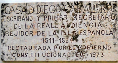
Casa Diego Caballero (also spelt Cavallero) was the writer and Secretary of the Real Audience from 1511 to 1554. He also owned one of the largest sugar mills of the time. This house was probably built in the mid-sixteenth century. He built many of the important houses of the era and many are still standing including the Casa del Santísimo Sacramento/ House of the Blessed Sacrament located across the street from his home.

+click to enlarge
Casa Diego Caballero
+click to enlarge
wall plack
Location: Calle Pellerano Alfau between Las Damas and Isabel la Católica. see the map (number 77)
Casa del Cordón/ House of Cords The oldest structure in the New World with 2 floors. This house is named such for the "Cord of San Francisco" carved in stone surrounding the doorway. It was built by Francisco de Garay who, when he originally arrived in the New World, was a servant of Christopher Columbus (Cristóbal Colón). Columbus taught Garay to be a Notary Public and he gained his wealth from investing in the mining of the country.
The beautiful house was the first stone house in the New World. It was built in the EIisabethian and Gothic styles of the time. The house was used as temporary housing for Diego Columbus, the son of Christopher Columbus, and his wife while the palace, their residence, was being built. This house also housed many of the noted persons of the time. It was a place of grand social gatherings and meetings of the important and "beautiful people" of the time. All waited on hand and foot by the black slaves.
This house housed the Real Audiencia. With the terrible and devastating invasion of Francis Drake in 1586, when he and his Pirates took over the city, this building was where the

+click to enlarge
Entry of Casa del Cordón
transactions took place for the inhabitants to buy back their city. They paid a heavy price of silver and gold to these English Pirates to get back their beloved city.
The Casa del Cordón is now occupied by the Popular Bank (Banco Popular) who took care of the restoration of this beautiful building. When you enter you will be amazed at the beauty inside, the floor and vaulted ceiling and the central court yard.
Directions: Calle Isabel la Católica and Emiliano Tejera see the map (number 34)


.jpg "Casa de los Medallones/")
+click to enlarge
Casa de los Medallones