This large gated cemetery with an area of 16,000 square meters and a 1.433 graves, has been around for more than 500 years. It was inaugurated in 1824. Buried beneath the soil is history in abundance. Yet we will never know all who are buried in this disorganized resting place as many of the graves are not marked.
Many of the founders, the people that created Santo Domingo, are buried here. The plagues that spread throughout the country are represented here amongst the graves many of which are children and infants. The dead from hurricane San Zenón that took many lives are represented here as well. Many different races and nationalities have been laid to rest in this bleak but interesting place. There are people from the Haitian occupation buried here with their tomb stones written in French. There are dead here from wars, The War of Restauración, Annexation to Spain, The War of Independence, The Intervention of the US Marines (6 Marines are buried here), There are tombs of many of the Dominican Republic Presidents here including Francisco Gregorio Billini Aristy, El Padre Billini and José Núñez de Cáceres (1772-1846). Take a walk here and view the tombs and the strange grave markers from times past.
There is information about a proposed restoration of the National Cemetery at the Colonial Zone News Blog here.
See a picture slide show of the Cementerio Nacional with many pictures and information of this Historical National Monument.
This cemetery has been declared a Patrimonio Cultural/ Cultural Patrimony historical site yet it is highly ignored by the Dominican peoples. Outside the gates at night can be seen the street people, sleeping on pieces of cardboard. There are rats scurrying along doing who knows what in the dark cemetery.
Passing by in the daylight one can always see dogs inside the gates. Sleeping on a grave. Could it be the grave of its master? One day I saw a dog laying atop a grave chewing on a large bone. Makes one think...
Location: Go to the beginning (west) of the Conde at Independencia Park. Turn left (south) walking in front of the park. Take the first road to the right (south), Ave. Independencia (at the end of Arz. Nouel the street name changes), and continue walking up this street (away from the Colonial Zone). The cemetery is 2 blocks up on the left. see the map (number 74)
+click picture to enlarge
monument Angel at Rest.
Cementerio Nacional de la Avenida Independencia/ National Cemetery on Avenue Independencia
This plaza is named after Fray/ Friar Las Casas. He was known as the Royal Protector of the Indians and a very respected person living here in the colonial time. This was the location of his home built in the mid 1600's. Now, it is a nice little plaza surrounded by a wall and fence. There are many well cared for plants and trees growing in the park, even a mango tree where if you are lucky you will be able to pick a nice fresh mango in season. It is open for concerts and special events and was once the home to the Feria Artesanal where artists would set up their booths and sell their craft and handmade items.
The grand modern statue of Fray Bartolomé Las Casas in the center of the park was created by Juan de Vaquero.
This is a small very quiet plaza whose surrounding buildings housed high church officials and church offices. In this plaza one can see the Arabian influence in the building style. Walking through or sitting in this plaza one has the feeling of serenity. It makes one feel silent and reverent. You can almost feel the presence of the cloistered monks who used this place to remain in silence. With the Cathedral de Santa Maria on one side, looming in its grandness and majesty and the small simple offices on the other side of the plaza it is a great place to feel the presence of God.
The plaza entrance is accessed through arched passages and can only be accessed during the day when the gates are unlocked. One of these arches is called the Puerta del Perdón/ The Door of Pardon. This archway leads to a small alley way type
This small plaza is dedicated to Father Francisco Xavier Billini. He is known as the protector of the poor man and also a great Philanthropist. His statue stands in the center of this plaza. Billini founded the Hospital de la Beneficencia which was the first charity hospital here in Dominican Republic. He also developed the lottery so as to help pay for these the poorest of patients.


This neighborhood park is a nice place to sit and wile away an afternoon. There are benches where you can sit under a tree, relax and watch the world pass by. In the night this place is over run by young people partying, drinking and listening to music. I call this park "the alternative lifestyle park" as it has a variety of visitors in the evenings. Artists and musicians, gay and strait, young and old. A very interesting place to observe and enjoy partying with a variety of humans.
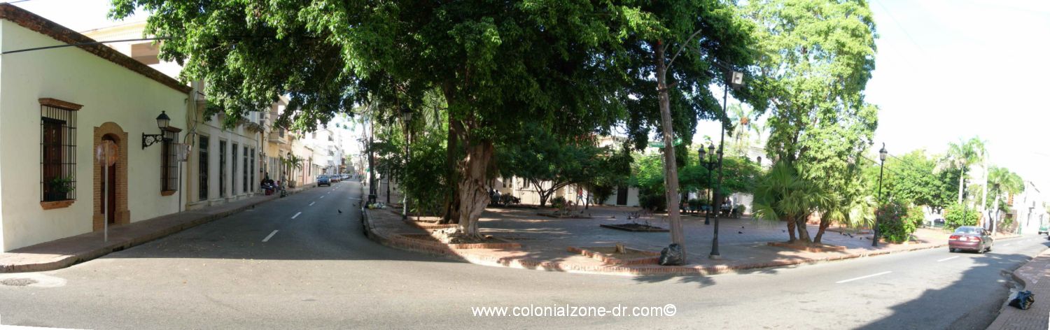
+click image to enlarge
Parque Duarte panoramic view.
path where the people of the colonial times liked to take an afternoon stroll. This path is called El Callejón de los Curas/ The Alley of Cures or the Priests Alley and it is a beautiful little stroll as it is laden with overhanging aromatic flowers and vines.
Located near this plaza was a colonial religious cemetery that is no longer there.
Location: Walking down (south) Isabel la Católica behind the Cathedral de Santa Maria at Colon Park. Directly behind the church behind the large black gates. see the map (number 52)
+click image to enlarge
Callejon de los Curas
Location: Walking from the Conde turn onto Hostos going south toward the sea. Past Parque Duarte to Padre Billini on the left behind a gated wall. see the map (number 60)
+click image to enlarge
Plaza Bartolomé de las Casas
Location: Walking from the Conde turn on Arzobispo Meriño south toward the sea. Walk about a block and a half and it is on the left side before you get to Padre Billini. see the map (number 58)
+click image to enlarge
Plazoleta Padre Billini

The Malecon has a park running along the sea side of this busy street running most of its entire length. The road can be a little dangerous to cross as pedestrians do not have the right of way so be very careful. Once you have crossed to the sea side it is a beautiful walk. There are many benches where you can have a spectacular unobstructed view of the Caribbean Sea. The rough coral edges make for a great place for the waves to crash upon. The spray of the water on days when the waves are strong can be very refreshing.
The original road was President Trujillo's dream. He wanted a road running along the sea. There were many problems building the avenue as many peoples personal properties had to be taken and some of the old forts had to be partially destroyed. The planning was not well done thus the road had to be built in sections the first beginning in 1931. The construction was done using prisoners and the most primitive tools. Originally Trujillo wanted the road named after himself but an act of congress the road was named after George Washington's and was inaugurated on the American heroes birthday on February 23, 1936.
The opening of the avenue was declared a holiday and all the houses in the area were decorated with Dominican and American flags. Trujillo gave the keynote speech in which many from the United States government were in attendance. The finale of the days events had the Dominican Army band playing.
There are little stops where you can get a drink or sandwich, sit and relax with the cool breezes blowing softly. In the evening there are more eating options on the sea side of the road at little kiosk type places or a restaurant. Many times throughout the year there are many free concerts along the road where it is shut off to traffic. It can be a fun time for all. The Carnival in Santo Domingo(pictures-new window) and most of the parades are held on this road.
There are many interesting statues and the obelisks to see on this road.
Location: Runs east and west along the sea. The official name is Avenida George Washington, Santo Domingo see the map (number 75)
about walking along the Malecon at night (will open in a new window)
+click image to enlarge
Malecon 2000 view of Oblisco Macho(top)
Avenida George Washington 1938 (bottom)
|
|

site map Copyright © 2005 - 2016 All Rights Reserved. Colonial Zone-Dominican Republic (DR)
Home | Calendar | Night Life/Dining | Sight Seeing | Pictures | Businesses | Artists | Food | Helps | History | Language | Music | Media | Pastimes | Products | Tradition/Legend | Links | About Us | Buy Mamajuana | News Blog | DR Gringa's Life Blog | Dominican Dog Blog

Custom Search
Parks/ Parques, Plazas and Plazoletas (Small Plazas) 2


Home | Dining & Night Life | Hotel | Sights | Pictures | Music | Colonial Zone Map | Hot Spots! Directory | Site Search

MENU
IN COLONIAL ZONE
THINGS DOMINICAN
If you found my web site useful please consider making a donation through Pay Pal . Thanks!

Our complete exchange rate tool.
Gracias a coinmill.com
Malecon - Avenida George Washington (This area has also been known as El Tripero, Malecón Padre Billini and La Boca del Infierno)


Parque Duarte
Duarte Park is rich in history. Haitian separatists fought for independence at this site in 1843. It was also the site of bullfights. The statue of Duarte in the center of the park was erected in 1930. The park faces the Capilla de la Tercera Orden Dominica (where the first university of the New World was founded in 1538). This square was also known as Anacaona Plaza, Santo Domingo Plaza and Plaza of the Ex-Convict Dominico.
Location: From the Conde turn south onto Padre Billini or Duarte. Walk in the direction of the sea almost 2 blocks. see the map (number 61)


Plaza Bartolomé de las Casas (history of Las Casas)

Plazoleta de los Curas

Plazoleta Padre Billini