Tag Archives: history

Earthquakes & Terremotos

Earthquake / Terremotos / Temblor de Tierra Information for
Dominican Republic

Earthquakes / los Terremotos/ Temblor de Tierra

Yes, we do have earthquakes in Dominican Republic. We call an Earthquake in Spanish a Terremoto or Temblor de Tierra. Whatever you want to call them we do have this earth-shaking phenomenon occurring here on our island and we do have many earthquakes. The island of Hispaniola does have seismic activity almost daily, as with many places throughout the world, but the activity is so small that usually it cannot be felt. Every so often the quakes are strong and they can be felt. You can feel the earth move and sway under your feet!

Fault Lines | Fault Line Map | What to Do | Largest Quakes in Dominican Republic | The Quake Sept. 2003 | Recommended Emergency Products | Links to Earthquake Related Web Sites

The island of Hispaniola, part of the Greater Antilles chain of islands, rose out of the sea due to volcanic action. Dominican Republic has a long history of volcanic and seismic activity. The tallest mountain on the island, and for that matter in all of the Caribbean, is Pico Duarte. This mountain was at one time an active volcano. It rose out of the sea starting with this mountain and it is still rising. Many of the under water caves are not under water now. Don’t worry about Volcanoes for now. There are no active volcanos on our island.

Fault Lines

There are two major fault systems or lines that run through the island. In the North Hispaniola Trench. It is located just offshore running parallel to the north coast. The other is the Septentrional Fault Zone which runs from the North Hispaniola Trench to the Cibao Valley and Santiago. The Septentrional Fault Zone is responsible for most of the earthquakes in Dominican Republic’s history.
View a PDF document of the fault lines going through Dominican Republic by www.ig.utexas.edu

The Puerto Rico Trench (on the Northern side of Puerto Rico and the Northeast tip of Dominican Republic), which is close to the Mona Passage, marks a boundary where the North American tectonic plate and the Caribbean tectonic plate slide past each other, with the North American plate also subducting or sliding beneath the Caribbean plate. With water depths of more than 8 km (5 mi) make the Puerto Rico Trench the deepest part in the entire Atlantic Ocean.(see the map and learn more)

The Mona Passage is the water pass that divides Puerto Rico and the Dominican Republic in the northeastern Caribbean. This area is very earthquake prone. Since the water level in this passage between the two islands is quite low it is very susceptible to Tsunamis. This passage has very fast flowing and dangerous waters with shifting currents that occur when the Atlantic Ocean and the Caribbean Sea meet.
http://soundwaves.usgs.gov/2007/05/

Fault Lines / Fallas Sísmicas

Map - Fault lines/ fallas sísmicas running through the island of Hispaniola.
Map – Fault lines/ fallas sísmicas running through the island of Hispaniola.

There are also many smaller fault lines/ fallas sísmicas running through the island of Hispaniola. This is a map from Emergency Operations Center (COE) showing all the lines running through Dominican Republic and Haiti.

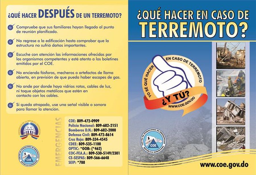
Brochures – What To Do

Below are the instructional brochures put out by the Emergency Operations Center about what to do before and after an Earthquake happens. They are in Spanish. Click on the images to see the images to enlarge.

COE Instructional Brochure - What to do before earthquake in Spanish
COE Instructional Brochure – What to do before earthquake in Spanish
COE Instructional Brochure - What to do after an  earthquake in Spanish
COE Instructional Brochure – What to do after an earthquake in Spanish

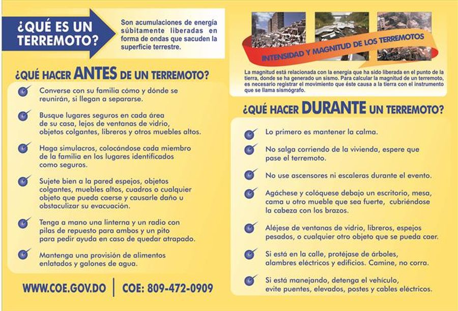
Many people say many different things one needs to do to be safe during an earthquake. Stand in a doorway, don’t stand in a doorway. Don’t go outside, get outside and away from buildings. Get under something inside your house, get in the “Triangle of Life” / “Triangulo de Vida” around a piece of furniture. While others say you need to “Drop, Cover, and Hold On.” / “Agacharse, cubrirse y agarrarse”. Our suggestion is to do a search and see what you should do in case an earthquake happens.

Make a plan with your family and loved ones what to do and where to meet in case of an emergency situation. We also suggest if you are coming on vacation don’t worry about it. Just come and enjoy. Leave all the worries at home and relax. Earthquakes do not happen often and the hotel staff will be there to inform all on their procedures.

The Largest Earthquakes

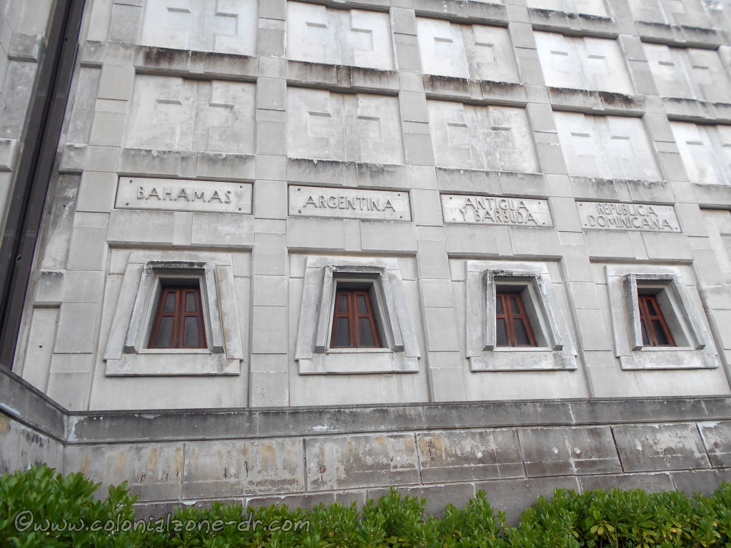
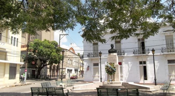
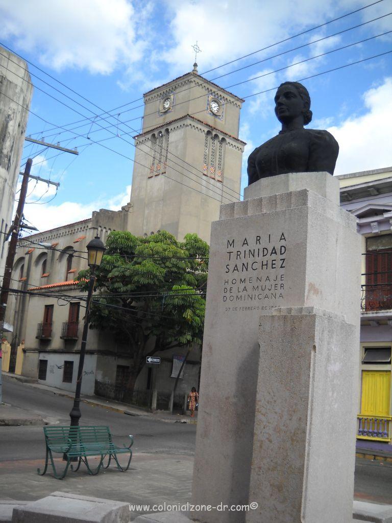
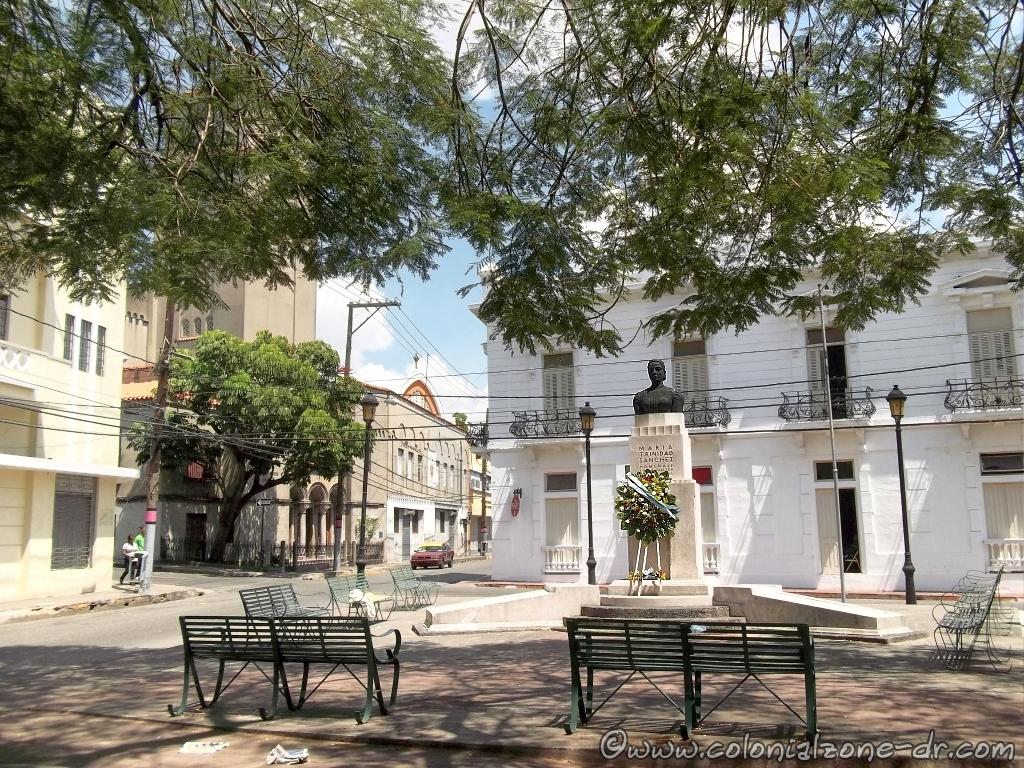
The largest earthquake on record in recent history for the Dominican Republic was August 15, 1946. It was recorded at 8.1 and centered in Matanza in Maria Trinidad Sánchez, Nagua on the northern part of the island (a large tsunami hit the coast from Arroyo Salado to Cabrera and left areas under water for about three weeks was recorded at that time).

Other notable quakes:
*1961 – 6.6 quake southeast of Santo Domingo.
*1971 – 6.0 quake registered in the Azua area.
*1991 – 7.0 quake recorded in the Central Mountains and San Juan de la Maguana area.
*March 1993 – a 5.2 earthquake affected the south and southwest parts of Dominican Republic along the Mona Passage.
*April 1993 – a 5.7 earthquake affected the Cibao region.
*June 1993 – a 5.1 earthquake affected San Francisco de Macoris area in the northeast.
*January 5th, 2012 – in Palmar de Ocoa (some information on the San Jose de Ocoa quake)
*January 22, 2012 – a 5.0 in the East near La Romana.
*January 23, 2012 – a 5.4 Rio San Juan.(some more information about this and more quakes in January 2012)
*May 28, 2014 – a 5.8 at Boca De Yuma – Mona Passage at 5:15PM
*February 4, 2019 – a 5.3 quake at 10:33AM. 31km SSE of Boca de Yuma, Dominican Republic. People felt it in Punta Cana, Santo Domingo, Haina, Bani, Las Terrenas and many other locations in the country.

There was a 9.0 earthquake when the Europeans occupied the island on December 2, 1562. It destroyed the cities of La Vega and Santiago. A quake estimated to be a 10.0 happened on October 18, 1751 and devastated the southern region. A terremoto estimated to be 11.0 happened on May 7, 1842 destroyed the north of Haiti and much of what is now the Dominican Republic.

There have been many earthquakes and tsunamis resulting from the tectonic-plate motions that have occurred in the history of the northeastern Caribbean.

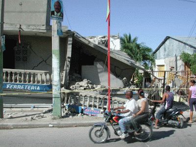
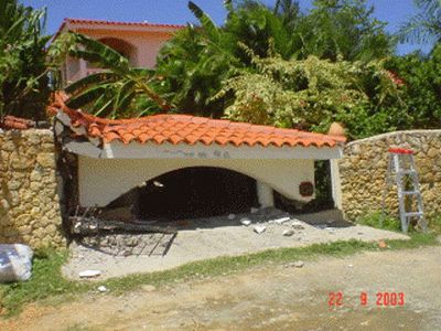
Sept. 22, 2003 Quake

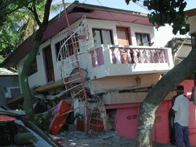
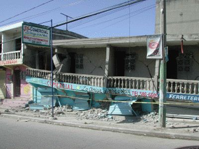
At 11:45 pm on 22 September 2003, a M 6.7 earthquake severely shook the northern part of Dominican Republic. It caused extensive damage to buildings in the major cities of Puerto Plata and Santiago along with landslides in the outlying areas. There were also several large aftershocks (over 200 in all) that happened in the days and hours following this quake.

Here are a few pictures of an earthquake that happened in September 2003. These were taken in the Puerta Plata area by our friend Cochman.

September 2003 Earthquake in Puerta Plata Dominican Republic house
September 2003 Earthquake in Puerta Plata Dominican Republic store
September 2003 Earthquake in Puerta Plata Dominican Republic observing the damage
September 2003 Earthquake in Puerta Plata Dominican Republic house

Recommended Emergency Products

The Earthquake Alarm (Amazon) can wake you up and alert you the moment a quake starts giving you more time to take cover.

*Operates off of a 9-volt battery.
*Loud distinctive alarm to wake you up.
*Can detect earthquakes miles away.
*Fully adjustable sensitivity setting. and more..(incluye instrucciones en espanol!)

I have heard many people use a detector and they say they work quite well. I recommend getting one if you live in any Earthquake prone area.

Another product that I read about is The Quake Escape

Ready America 70280 Emergency Kit, 2-Person, 3-Day Backpack. A backpack that keeps supplies at the ready. (Amazon)

*Sustains two people for three days
*Includes food, water, and emergency blankets
*One 33-piece first aid kit

NOAA Weather Radio and Solar Emergency Survival Device (Amazon)

*AM/FM Transmission
*Windup Power for Emergencies, Tornadoes, Hurricanes
*Micro USB Charger and Power Bank for Cell Phones and Electron

*The Dominican Republic Emergency Operations Center (COE). They now offer a downloadable App for emergency Alerts – Alerta COE.

Other instructions on how to prepare for an earthquake and other interesting web sites about earthquakes.
*ready.gov/earthquakes

*Acqweather, complete information on the weather in Dominican Republic.SPANISH

*Global Earthquake Monitor – list, news and maps of recent quakes worldwide.

*Create an Earthquake Emergency Handbook

*This is the Earthquake information from the Puerto Rico Seismic Network

*Earths view of Earthquake activity

*Quakes – Live Earthquakes Map and other interesting maps.

*Earthquake forecasting and hazard analysis.

*USGS Earthquakes Hazards Program has all the Earthquakes listed in the world for the last 7 days. The latest in USA and surrounding areas (including Dominican Republic – sometimes called Mona Passage) with an earthquake of Magnitude 2.5 or greater. All other areas of the world are listed when they have a quake with a Magnitude 4.0 or greater.

Faro a Colón / Columbus Lighthouse

Faro a Colón/ Columbus Lighthouse

The Faro a Colón/ Columbus Lighthouse is a massive building shaped like a cross located in Eastern Santo Domingo. It is both a Museum and Mausoleum, it is said to house the remains of Christopher Columbus.

The Faro or Lighthouse was built to commemorate the 500th anniversary of the arrival of Admiral Cristobal Colón / Christopher Columbus to Santo Domingo in Las Americas in 1492. It sits on a large lot of land with reflecting pools on either side of the entrance (the only time there is water in the pools now is if it rains). There is a sidewalk where you can walk completely around the monstrous building and take in the views of the Caribbean Sea and the city of Santo Domingo in the distance. There are also pathways on the property where you can meander about.

The Design | Inguration (Pope-Mobile) | The Entrance (Isabel la Católica) | Escudo de Armas | The Building and Light | Columbus Remains | Hours-Location |

The Faro a Colón standing majesticly as the sun brightens the sky.

The Design

This monuments design was chosen out of many applicants from the world over. The jury chose the design of Joseph Lea Gleave from England. His design was described as “an enormous cross-shaped structure designed to last for all times”. The jury described his design in this way, “THE DESIGN, MAKING WONDERFUL USE OF LIGHT, TAKES REFUGE IN A DIRECTNESS, SIMPLICITY AND FORCE WORTHY OF THE MONUMENTS OF THE AGES. THE DESIGN IS SYMBOLIC, BUT NOT TO THE EXTENT WHERE SYMBOLISM INTERFERES WITH THE SIMPLE BEAUTY OF THE WORK AS ARCHITECTURE. SEEN FROM THE AIR, OR FROM ITS SURROUNDINGS, THE SIMPLE MASS BECOMES A NOBLE ELEMENTAL FEATURE OF THE GROUND AND OF A CHARACTER WORTHY OF THE STEADFAST COURAGE AND FAITH OF THE GREAT DISCOVERER IT COMMEMORATES”.

The Faro a Colón entrance.

Inguration

The Columbus Lighthouse was inaugurated October 6, 1992 by President Joaquin Balaguer Ricardo. At the commemoration ceremony, the remains of Columbus were carried from the First Cathedral of the Americas through the streets, across the river and to their new resting place inside this enormous monument.

The Popemobile / Papamóvil located outside of the Faro a Colón. Pope John Paul II rode in it when he visited Oct. 9-to-13, 1992 for the inauguration of the Lighthouse.

The ceremony was even attended by Pope John Paul II. The Popes Pope-Mobile / Papamóvil can be seen parked outside of the entrance to the Faro.

Isabel la Católica statue at the Faro a Colón

The Entrance

A statue of Queen Isabel la Católica marks the entrance to the Faro as you approach on Ave. Mirador del Este. Queen Isabel la Católica, Queen of Castile, commissioned Cristobal Colón voyage to the New World.

Many different nations falgs line the walkway entrance to the Faro a Colón / Columbus Lighthouse

There is a large paved walk and grand stairs that lead up to the entrance of the Faro. The walkway is lined by many different countries’ flags waving in the breeze.

Christopher Columbus, Coat of Arms / Cristóbal Colón, Escudo de Armas

Escudo de Armas

On the entrance walkway you will notice the Christopher Columbus, Coat of Arms / Cristóbal Colón, Escudo de Armas. It is divided into 4 sections.
1) A castle of gold / Un castillo de oro
2) Lion crowned in gold with silver background / En campo de plata un leon rampante de gules coronado de oro
3) Islands of gold in a blue background / En campo de azur unas islas de oro
4) Five gold ancors in a blue background / En campo de azur cinco ancoras de oro, puestas en aspa.
Entado en punta de oro con una banda de azur y el jefe de
gules.


The bust of President Joaquin Balaguer Ricardo at the entrance to the Faro a Colón

Climbing the stairs to the front gate there is a bust of President Joaquin Balaguer watching over all who enter.

Looking in the side entrance of the Faro a Colón

The museum and chapel inside are a repository for numerous documents and artifacts associated with the early Spanish Colonial times. There are rooms dedicated to the Latin America Countries displaying many different artifacts and items of interest from the represented country.

The Faro a Colón / Columbus Lighthouse reflected in the rain water filled reflecting pool.

The Building and Light

The Faro a Colón is 693ft (211m) long East to West and 195 long feet North to South. This massive monument is 45 feet high. It was built in the shape of a cross at a 45-degree angle. It has 4 bronze lions and the feminine figurine that represents the Dominican Republic.


Columbus remains guarded by 2 lions inside the Columbus Lighthouse.

The building, in my opinion, is quite ugly from the outside. Its huge grey shape can be seen from a great distance even high in the air. The most impressive part of the structure is when they turn on the 157 beams of light illuminating the night sky with its brilliant cross. Now, the light is only turned on for special occasions because of the cost and problems with the electricity in the country. The light, it is said, can be seen in Puerto Rico on a clear night. It is very beautiful and quite impressive to see this cross-shaped beam of light shining in the night sky.

The entrance walk and stairs to the Faro a Colón

The exterior of the building has a representation of 43 different countries. Most are countries in The Americas but there are others included.

Nicaragua. Panama. Paraguay. Peru. Republica Dominicana. Puerto Rico. San Cristobal. Y Nevis. Republica Dominicana. Santa Lucia.
San Vincent. Y Las Granadinas. Suriname. Trinidad Y Tobago. Uruguay. Venezuela. España. Portugal. Italia. Inglaterra. Japon. Aruba. Curazao. Republica Dominicana. Mexico. Jamaica. Honduras.
Haiti. Guyana. Guatemala. Granada. Estados Unidos. El Salvador. Ecuador. Dominica. Cuba. Costa Rica. Colombia. Chile. Canada. Bolivia. Brazil. Belice. Barbados. Bahamas. Argentina. Antigua Y Barbuda. Republica Dominicana.

Countries named on the exterior of the Faro a Colón / Columbus Lighthouse

43 countries (48 blocks).
*Republica Dominicana holds 4 blocks.
*San Cristobal Y Nevis (Saint Kitts and Nevis) is one country with 2 blocks.
*San Vincent Y Las Granadinas is one country with 2 blocks.

Countries named on the exterior of the Faro a Colón / Columbus Lighthouse

Columbus Remains

There is still much debate on whether the remains located in the Faro really belong to Christopher Columbus. Spain also claims to have his remains. Neither country wants DNA tests done on the bones in their possession so it will remain a mystery. To read more on this

Columbus Remains Found In Spain – CBSNews

Another interesting read in detail about the Faro and more. Cowan-Richter-The Faro a Colon.


The Faro a Colón with a beautifully lit sky.

Hours-Location

The lighthouse was remodeled in August 2008 and most recently in 2018. The streets have been repaved, the interior has been cleaned and bad floors replaced. New lighting has been installed.

Hours: Tuesday to Sunday 9am to 5pm (there is a small admission fee) Phone – 809-591-1492

Directions: Ave. Mirador del Este, Santo Domingo Este. It is about a 30 minute walk from Plaza España in the Colonial Zone.


Parque Plaza History Maria Trinidad Sanchez

Parque – Plaza Maria Trinidad Sánchez And The History Of María

This small triangle-shaped park is dedicated to the great woman patriot Maria Trinidad Sanchez. She is the Aunt of one of the Fathers of the Nation, Francisco del Rosario Sanchez. She represents the best of female leadership at the time. In this tree filled park is a bust of this brave Dominican woman with benches surrounding.

Maria and Concepción Bona created the first Dominican flag.

Parque Maria Trinidad Sánchez under the Flamboyant Tree.

Dominican Activist

Maria was a Dominican activist who actively participated in the independence of the Dominican Republic against the Annexation to Spain. She collaborated with Los Trinitarios, who shared the idea of a free and independent republic. On February 27, 1844, at the peak of the battle, she carried gunpowder to make the gun cartridges used that night underneath her skirt.

Maria Sanchéz was very involved in the conspiracy of 1845 against General Pedro Santana who later became president. Maria and the others involved were caught and imprisoned. She was put on trial for conspiracy. When questioned about the location of her nephew, Francisco Sanchez, she refused to tell where he and the other members of the Trinitarios were hiding.

This heroic deed, among others, led to her execution. She was lead out of her prison in Fortaleza Ozama to the Cemetery where she was to be shot. As she passed by the Puerta del Conde (Parque Independencia) she exclaimed: “Dios mío, cúmplase en mí tu voluntad y sálvese la República”/ “My God, let your will be done in me and save the Republic.”

Bust of Maria Trinidad Sánchez in the park named after her.

First Victim of Political Crimes

Maria was one of the first victims of political crimes in the history of the Republic. She was executed, along with her nephew Andrés Sánchez, because of her actions against the annexation of the country to Spain.

Maria Trinidad Sanchez was shot on February 27, 1845 on the first anniversary of the founding of the Republic. She was executed because of her dedication and love for the country and for her desire for the sovereignty of the Dominican Republic.

Maria Sanchez – Born June 16, 1794 – Died February 27, 1845. Her body is interred in the Panteón Nacional in Colonial Zone.

Plaza - Parque Maria Trinidad Sánchez, Zona Colonial.
Plaza – Parque Maria Trinidad Sánchez, Zona Colonial.

Location:

Corners of Luperon, Calle Mercedes and 19 de Marzo. From Calle el Conde turn up (north – away from the sea) on 19 de Marzo, 2 blocks on the left.