If you found my web site useful consider making a donation through Pay Pal.
Thanks!

|
|


Then and Now - Ave U.S. Marine Corp.
Home | Dining & Night Life | Hotel | Sights | Pictures | Music | Colonial Zone Map | Hot Spots! Directory | Site Search
site map Copyright © 2005 - 2015 All Rights Reserved. Colonial Zone-Dominican Republic (DR)
Our complete exchange rate tool.
Home | Calendar | Night Life/Dining | Sight Seeing | Pictures | Businesses | Artists | Food | Helps | History | Language | Music | Media | Pastimes | Products | Tradition/Legend | Links | About Us | Buy Mamajuana | News Blog | DR Gringa's Life Blog | Dominican Dog Blog | Web Designer
[TOP]

Custom Search
Then & Now
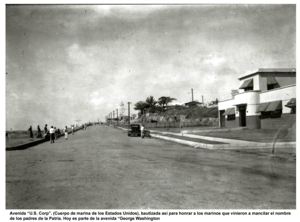
Avenida "U.S. Corp". (Cuerpo de marina de los Estados Unidos), bautizada así para honrar a los marinos que vinieron a mancilar el nombre de los padres de la Patria. Hoy es parte de la Avenida "George Washington"
Avenida "U.S.Corp". (Marine Corps of the United States), named to honor the sailors who came to honor the name of the Founding Fathers. Today it is part of the Avenue "George Washington"
This area along Ave. George Washington between Rio Ozama and Calle 19 de Marzo, Ciudad Colonial at the faro / lighthouse of Fuerte San Jose (this lighthouse was demolished by Trujillo) was designated for this muella / port.
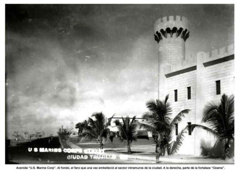
The large new tower was build to divide the old city from the new road Trujillo build to go among the sea.
This road, build by Presidente Trujillo when the Ciudad Colonial was called Ciudad Trujillo, has had many names. Avenida "U.S. Marine Corp. Avenida del Puerto. Avenida George Washington. Avenida Francisco Alberto Caamaño Deñó. Paseo Presidente Billini. I do not know where one part of the road ends and another begins. Most know the road as The Malecon.
This building houses the Marinas de Guerra / Marines of War base on the west side of Rio Ozama. It is the offices of the Dirección Nacional de Pesca / Director of Fisheries and the Comandancia de Puerto / Port Command Post.
The building was inaugurated, as far as I can tell, in 1939. The building is shaped to look like a ship with its rounded front and the look-out area on top.
Across the street is the Muelle / Port and La Dirección General de Aduanas (DGA) / The Directorate General of Customs.
Located: Avenida del Puerto, Ciudad Colonial, Santo Domingo República Dominicana. Walking - go down the Escaleras de las Damas / Stairs of las Damas at the end of Calle las Damas on the Malecon.
Avenida "U.S. Marine Corp." Al fondo, el faro que una vez embelleció al sector intramuros de la ciudad. A la derecha, parte de la fortaleza "Ozama".
Avenida "U.S.Marine Corp." In the background, the lighthouse that once embellished the sector within the city walls. To the right of the fort "Ozama"
+click images to enlarge
(left) Avenida "U.S.Corp" around the 1940's / (right) Avenida George Washington today 2014
+click images to enlarge
The Marinas de Guerra / Marines of War base on the west side of Rio Ozama. Dirección Nacional de Pesca y Comandancia de Puerto.
These pictures were taken in (left) 2013 and (right) 2014
+click images to enlarge
(left) circa 1940 The Marinas de Guerra base, Ave U.S. Marine Corp. and the wall surrounding Fortaleza Ozama / (right) The wall surrounding Fort Ozama 2013
Please let me know if I have any information or dates incorrect. I did my best trying to find some information about this building and had to piece together what little I could find. Thank you.


.jpg)

