If you found my web site useful consider making a donation through Pay Pal.
Thanks!

|
|

Custom Search
Gracias a coinmill.com


Dominican Republic National Parks and Protected Areas
Home | Dining & Night Life | Hotel | Sights | Pictures | Music | Colonial Zone Map | Hot Spots! Directory | Site Search
site map Copyright © 2005 - 2016 All Rights Reserved. Colonial Zone-Dominican Republic (DR)
Our complete exchange rate tool.
Home | Calendar | Night Life/Dining | Sight Seeing | Pictures | Businesses | Artists | Food | Helps | History | Language | Music | Media | Pastimes | Products | Tradition/Legend | Links | About Us | Buy Mamajuana | News Blog | DR Gringa's Life Blog | Dominican Dog Blog | Web Designer
[TOP]
Important Stuff - National Parks & Reserves
Important Stuff | Important Emergency phone numbers - Telephone and Internet Services | Flag, Shield and National Symbols | Dominican Republic Facts | Environmental Issues | National Parks & Reserves | National Songs | Religious Beliefs | Charities | Creatures | Trivia and Useless Facts | Live Cameras/ Camaras en Vivo | Public Services | Travel - Flight Information |
National Parks and Reserves
Dirección Nacional de Parques | La Loma Guaconejo | Las Neblinas | Loma Barbacoa | Scientific Reserves | Estero Hondo | Villa Elisa | Ebano Verde | Lago Enriquillo and Isla Cabritos | Los Haitises | Parque Nacional del Este | Montecristi National Park | Cuevas de Borbón | Cordillera Central

Dirección Nacional de Parques (DNP)
A visit to forest reserves requires a permit from the DNP or from the authorized administration office at each park. The cost of the permit is about RD$50 (could be more money now), which does not cover the boat fare for visits to Los Haitises or Isla Cabritos. A DNP publication, Sistema de áreas protegidas de República Dominicana, describes each park and gives details on how to reach it (about $12 US )
Contact: 809-472-4204/4104 E-Mail: DNP@codetel.net.do
Directions: Avenida Máximo Gómez, Santo Domingo
La Loma Guaconejo in María Trinidad Sánchez province, covers a range of mountains of great beauty. It has several rivers and small streams that form waterfalls. These protected forests are well preserved and the pristine ecosystems are of great scientific and botanical interest.
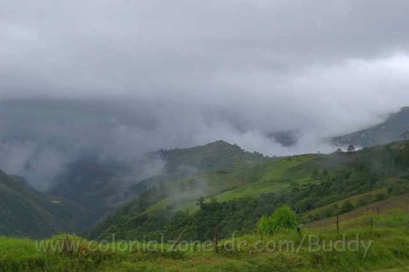
Las Neblinas (Mountain Mists) between Bonao and La Vega with an area of 40.7 square kilometers. The mountains always have cloud cover that looks like the mountain is covered with smoke. This area was declared protected in 1996.
Loma Barbacoa is located between the provinces Peravia and San Cristóbal. This is a high rainfall area. It is the watershed of several rivers in the country, so its main function is water conservation
Banco de la Plata and la Navidad Scientific Reserves located in the Bay of Samaná is a marine mammal sanctuary. It was declared protected in 1986 and has a marine extension of 32.936 square kilometers. Its main attraction is the presence of humpback whales between January and April, when they come to the area to mate and give birth.
Estero Hondo in Puerto Plata is a marine animal sanctuary with coral reefs in excellent condition. Here you can observe a highly diverse marine life. The sanctuary includes wetlands and pristine mangrove lagoons. The main attractions are the manatees that live in its waters. Here you will find the largest population of these species of marine mammals in the country.
Villa Elisa located in Guayubín, Monte Cristi province. Here you will find a wide variety of orchids, 138 different flora, 28 of which are endemic species. There are 23 species of birds including parrots, a variety of the woodpecker and the "cao" which are on the endangered list.
Ebano Verde Reserve is located between the municipalities Constanza and Jarabacoa, La Vega. It was created to safeguard the largest population of trees on the island. Water resources are also preserved in the reserve, through rivers (ríos) and streams (arroyos) that supply water to the communities in the lowlands. There has also been reported 687 species of plants, 159 are endemic to the island and nine exclusive of the reserve. Wildlife species are mostly birds, 59 species, of which 17 are endemic. Also they found the presence of one of the most unique mammals on the island, the Solenodon, which is in danger of extinction.
Lake Enriquillo/ Lago Enriquillo (see some pictures of Lago Enriquillo)
This 13 mile long lake (aproximatiley 300 km²) is in an out of the way area in the southwest,western part of the Hoya de Enriquillo, very near to the Haitian border. It is the lowest point in the entire Antilles, 114 feet below sea level. Lake Enriquillo is 3 times saltier than the ocean. It is a great spot to see crocodile (Caimans), flamingo, and iguanas.
The lake has grown enormously to almost 400 square kilometers. It keeps growing. Much of the surrounding farmland has been covered by salt water. The island in the center is getting smaller and smaller.This is affecting the creatures living in the area as well as the people and lands.
The Isla Cabritos National Park/ Little Goats Island is in Lago Enriquillo. This island has a very unique habitat. The original vegetation that once grew on this small island was lost to the goats and cattle that once grazed there and also due to the collection of timber. Now the park has present a large population of wildlife. The turn around is amazing to behold. The new vegetation includes 106 species of plants, and 10 types of cactus. The area also boasts a large crocodile-caiman population. An endemic species of iguana along with other species of reptile populate the island. There are 62 different species of birds that have also been identified: five aquatic, 16 shore, and 41 land birds. 45 of these species are native to the island. Some of the birds included are the manuelito, the great hummingbird, the querebebé (which is best heard at sun down), and the cu-cú (which sings at dawn and dusk, and nests in an excavated hole in the desert.
You can visit the lake and Isla Cabritos, which is in the center of the lake, by boat with an authorized guide from the National Park Station in the town of La Descubierta, on the lake's northwestern shore.
Directions: Highway 46 west from Barahona, in the direction of Neyba toward the Border of Haiti, Dominican Republic
A little more information about the Lago Enriquillo in the lakes and rivers section.
+click image to enlarge
Las Neblinas where the clouds touch the mountains
Los Haitises (means earth high land of mountains)
Nothing can compare to this twelve hundred square kilometer/ 78 square mile coastal region park. It is home to of the most important biodiverse ecosystems on the island and in the entire Caribbean. This area has mangrove swamps where manatee like to hang out in the roots. The land here is made up of strange rock formations called mogotes and karst hummocks that emerge from the sea. There are spectacular mountains, hills and valleys. There are many Taino caves with remains of their cave art, one of which is Cueva del Angel, a cave with many birds. This area supplies much of the water for the area. It is a humid tropical forest. Only a small portion of this protected land is accessible and then only with organized tours. It is a beautiful spot frequented by Dominicans and tourists alike for its exquisite natural beauty. The only way to visit this area is by an arranged tour. There is a fee for entering this area plus the guide service. It is well worth the price.
Directions: Gonzalo, from Sabana de la Mar to the Bay of Samaná
There has been much controversy of late about the Dominican government placing a cement factory on the edge of this protected area. They are worried about the water that supplies over 40% of the island being polluted.
Parque Nacional del Este (which includes Isla Soana)
Located in the southeastern part of the Dominican Republic, this park has become a symbol of the challenges of trying to safeguard ecosystems against development. The area consists of 190,267 acres of tropical forests, abundant caves (with samples of pre-Columbian Taino art on the walls), streams, coral reefs, remote beaches, lush vegetation and limestone bedrock. Significant features include the areas frigate bird and manatee populations. Known for being the habitat of the now scarce paloma coronita (crowned, or white-headed dove), the rhinoceros iguana and several turtle species. Tickets to enter the park need to be purchased in Bayahibe.
Directions: On the peninsula south of San Rafael del Yuma. Adopt a Reef in Parque de Este
+click image to enlarge
Entrance to Parque Nacional del Este
Montecristi National Park in the Northwest area of the island contains marine and land ecosystems, a coastal lagoon (Laguna de Saladillo) dry subtropical forest and Cayos Siete Hermanos (the Seven Brother Keys). The Southwest area Sierra de Bahoruco has an important mountain range, is a forested highland with 52% of the orchids found in the entire Dominican Republic along with many species of birds. Also here is the Southern most tip of Barahona, The Jaragua National Park (mostly dry forest), which includes Isla Beata (Beata Island).
Directions: on the Haitian border
The Anthropological Reserve of Cuevas de Borbón in San Cristóbal was extended in 1996 to protect the El Pomier caves threatened by limestone quarrying. These caves have an enormous archaeological value, with over 4,000 wall paintings and 5,000 rock drawings. The 590 pictograms in the first cave are ranked as the most important cave painting site in the Caribbean region. Admission is RD$5.
Park Armando Bermúdez and José del Carmen Ramírez, the pine forests on the Cordillera Central mountain range (see picture of these mountains) These are the only extensive forest areas left in Dominican Republic. Fire and the small land holdings have resulted in the loss of many of the islands virgin forests. We hope that the effort of protecting these parks will turn back the clock and give them a chance. A pilot reforestation project was started near San José de las Matas, under Plan Sierra to add to this effort. With these and other plans being created we hope to divert the complete loss of our forest areas for generations to come.
For information about El Jardín Botánico Nacional Dr. Rafael M. Moscoso/ The National Botanical Gardens information on the Sights pages.

[TOP]
Many maps to chose from. Browse our Dominican Republic map collection


.jpg)
