Weather Basics
What to expect from the weather (more or less) – Temperature Variations – Latitude-Longitude – Time Zone – Weather Alerts – Weather Stations – Fahrenheit to Celsius – Civil Defense Alerts – Emergency Operations Center – Wildfire Picture
Hurricane, Cyclone and Tropical Storm Information for Dominican Republic Hurricane –
Juracán – Hurricane Season – Categories – Warnings – What To Do – Dominican Republic Emergency Center Pamphlet – Taking Care of a Pet – Water Vapor Map Links – Links to Hurricane Related Web Sites – Tropical Storm Jeannie
EARTHQUAKES & TERREMOTOS
Fault Lines – Fault Line Map – What to Do – Largest Quakes in Dominican Republic – The Quake Sept. 2003 – Recommended Emergency Products – Links to Earthquake Related Web Sites
Tsunami / Maremoto
Significant Tsunamis in DR | Districto Nacional Flood Zone | Official Warnings and Alerts | Warning Signs | Survival | Links to Tsunami Related Web Sites
These links are to the old html non-responsive website until I can get them added to the new design.
Tsunami (tsoo-NAH-mee) is Japanese for “great harbor wave.” This wave can speed across the ocean at 500 miles (805 kilometers) an hour. When viewed in the deep waters the waves are only a few feet high. But watch out when the waves come close to shore and the more shallow waters. These little waves swell with energy and grow in height. Usually a second wave follows the first in about 15 minutes followed by others. These can last up to 2 hours or more. There are Tsunamis in Dominican Republic. Many have been recorded in history.
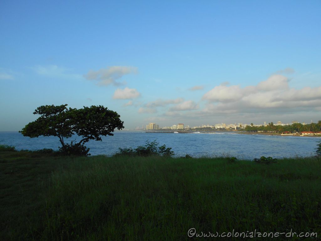
A view of the Caribbean Sea and Santo Domingo in the distance.
Significant Tsunamis in DR
There have been 10 significant documented tsunamis in the Caribbean since 1492. Not only can an earthquake cause a tsunami but also landslides and volcanic eruptions can trigger a giant wave.
Tsunamis in DR:
*October 11, 1918 – Small tsunami on the coast of Punta Cana killing a person.
*August 4th, 1946. This destructive tsunami was triggered by a magnitude 8.1 earthquake in the Dominican Republic. It killed about 1,800 people in the Caribbean. The natural phenomenon had waves over 10 meters high causing extensive damage to the northeastern coast of the Dominican Republic, according to contemporary reports in some low places the sea came up to 1500 meters inland. Reports say that the town of Matanzas was destroyed and an estimated 500 deaths occurred in that town alone. They say that one could walk underneath the pier in Puerta Plata, in the northern part of Republica Dominicana, because the retreat of the sea was so great. Read an account of the August 4th disaster.
We had a real tsunami warning after the 7. Earthquake that devastated Haiti in 2010. It was declared for Cuba, Bahamas and the Dominican Republic. Witnesses claimed that in the Dominican town of Pedernales the sea moved away. Shortly after the alert was made it was withdrawn.
Dominican Republic has set up mock tsunami drills in different areas throughout the country. These drills were executed very well. There are warning plans in place since an approaching tsunami cannot be felt as an earthquake can. A tsunami can sneak up on a person. The Caribbean Tsunami Information Center (CTIC) has been set up for this purpose.
Districto Nacional Flood Zone
The flood zone in the event of a tsunami can be from two kilometers from the coast or 20 meters high. An example of how far the flood Zone is in the National District, Santo Domingo that would be from the Avenida George Washington covering much of the Autonomous University of Santo Domingo, Gascue and the Colonial Zone.
Official Warnings and Alerts
The warnings and alerts and what each of the different warnings mean:
*Warning: Earthquake occurred. Tsunami may have been generated. Arrival times 2 hours
*Watch: Earthquake occurred. Potential resultant tsunami not measured. Arrival times 3 to 5 hours
*Info Bulletin: Earthquake occurred but not sufficient to generate a damaging tsunami
*Info Message: Earthquake occurred but not magnitude too weak to generate tsunami.
See a Map of the Caribbean with respect to the Tsunamis in the Caribbean area. Tsunami Messages for All Regions in the past 30 days. Tsunami Warning Center – Caribbean Sea.
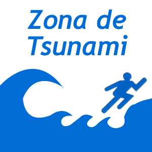
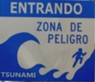
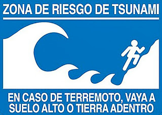
Warning Signs
Tsunami and Tidal Wave warning signs and evacuation routes signs.
Evacuation sign in case of tsunami “tsunami” / Señal ante alerta de tsunami.
Zona de Tsunami – Tsunami Area signTsunami Warning Sign – Entrando Zona De Peligro – Entering a Dangerous AreaTsunami Warning Sign – Zona De Riesgo De Tsunami. En Caso De Terremoto, Vaya A Suelo Alta O Tierra Adentro – Tsunami Risk Zone. In Case of Earthquake, Go To High Ground Or Inland
Survival
The best way to survive a Tsunami is to pay attention to the warnings put out by the government.
*Abandoning your belongings and home and get to high ground FAST.
*If getting away is not an option go to a tall building, climb a tree, do whatever you can to get high.
*If all else fails find something that floats and hold on for dear life.
*Stay wherever you found refuge and wait to be sure the tsunami is really over.
Links for more information and to learn in more detail about Tsunamis and Tsunami Stories.
*The Intergovernmental Coordination Group for the Tsunami and other Coastal Hazards Warning System for the Caribbean and Adjacent Regions (ICG/CARIBE EWS) was established in 2005 as a subsidiary body of the IOC-UNESCO with the purpose of providing efficient assistance on tsunami risk reduction to Member States in the Caribbean region after the lessons learnt from the 2004 Indian Ocean tsunami. The newly established Caribbean Tsunami Information Center (CTIC). The IOC Tsunami Programme (Intergovernmental Oceanographic Commission Tsunami Programme) http://www.ioc-tsunami.org/ is part of UNESCO (United Nations Educational Scientific and Cultural Organization)
*An excellent brochure put out by The United States Geological Survey (USGS) “Surviving a Tsunami – Lessons From Chile, Hawaii, and Japan.” Actions that saved lives, and actions that cost lives, as recounted by eyewitnesses to the tsunami from the largest earthquake ever measured, the magnitude 9.5 earthquake in Chile on May 22, 1960. http://www.ioc-tsunami.org/images/stories/documents/usgslessons_e.pdf
Earthquake / Terremotos / Temblor de Tierra Information for
Dominican Republic
Earthquakes / los Terremotos/ Temblor de Tierra
Yes, we do have earthquakes in Dominican Republic. We call an Earthquake in Spanish a Terremoto or Temblor de Tierra. Whatever you want to call them we do have this earth-shaking phenomenon occurring here on our island and we do have many earthquakes. The island of Hispaniola does have seismic activity almost daily, as with many places throughout the world, but the activity is so small that usually it cannot be felt. Every so often the quakes are strong and they can be felt. You can feel the earth move and sway under your feet!
The island of Hispaniola, part of the Greater Antilles chain of islands, rose out of the sea due to volcanic action. Dominican Republic has a long history of volcanic and seismic activity. The tallest mountain on the island, and for that matter in all of the Caribbean, is Pico Duarte. This mountain was at one time an active volcano. It rose out of the sea starting with this mountain and it is still rising. Many of the under water caves are not under water now. Don’t worry about Volcanoes for now. There are no active volcanos on our island.
Fault Lines
There are two major fault systems or lines that run through the island. In the North Hispaniola Trench. It is located just offshore running parallel to the north coast. The other is the Septentrional Fault Zone which runs from the North Hispaniola Trench to the Cibao Valley and Santiago. The Septentrional Fault Zone is responsible for most of the earthquakes in Dominican Republic’s history.
View a PDF document of the fault lines going through Dominican Republic by www.ig.utexas.edu
The Puerto Rico Trench (on the Northern side of Puerto Rico and the Northeast tip of Dominican Republic), which is close to the Mona Passage, marks a boundary where the North American tectonic plate and the Caribbean tectonic plate slide past each other, with the North American plate also subducting or sliding beneath the Caribbean plate. With water depths of more than 8 km (5 mi) make the Puerto Rico Trench the deepest part in the entire Atlantic Ocean.(see the map and learn more)
The Mona Passage is the water pass that divides Puerto Rico and the Dominican Republic in the northeastern Caribbean. This area is very earthquake prone. Since the water level in this passage between the two islands is quite low it is very susceptible to Tsunamis. This passage has very fast flowing and dangerous waters with shifting currents that occur when the Atlantic Ocean and the Caribbean Sea meet. http://soundwaves.usgs.gov/2007/05/
Fault Lines / Fallas Sísmicas
Map – Fault lines/ fallas sísmicas running through the island of Hispaniola.
There are also many smaller fault lines/ fallas sísmicas running through the island of Hispaniola. This is a map from Emergency Operations Center (COE) showing all the lines running through Dominican Republic and Haiti.
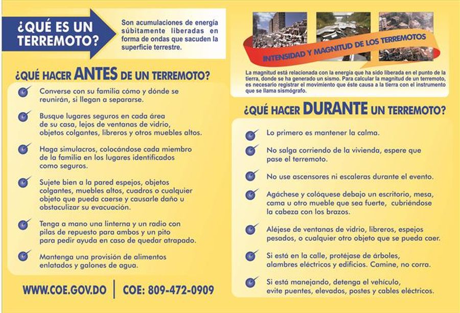
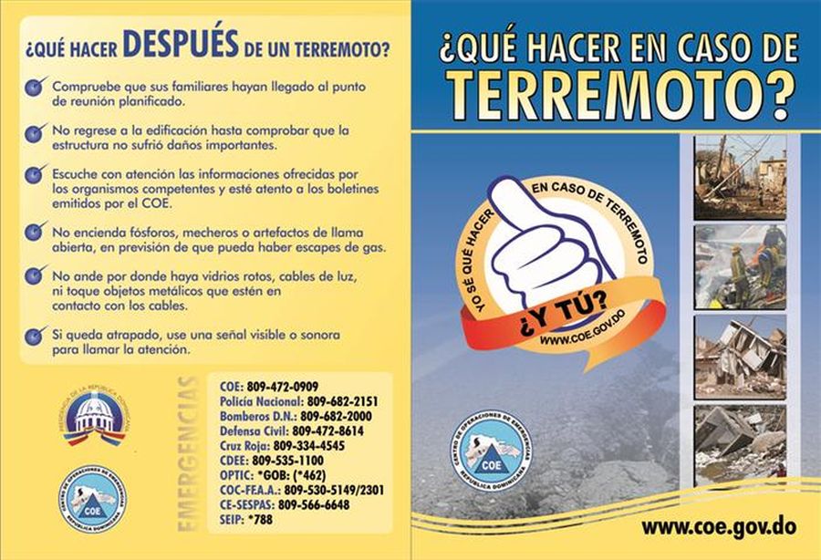
Brochures – What To Do
Below are the instructional brochures put out by the Emergency Operations Center about what to do before and after an Earthquake happens. They are in Spanish. Click on the images to see the images to enlarge.
COE Instructional Brochure – What to do before earthquake in SpanishCOE Instructional Brochure – What to do after an earthquake in Spanish
Many people say many different things one needs to do to be safe during an earthquake. Stand in a doorway, don’t stand in a doorway. Don’t go outside, get outside and away from buildings. Get under something inside your house, get in the “Triangle of Life” / “Triangulo de Vida” around a piece of furniture. While others say you need to “Drop, Cover, and Hold On.” / “Agacharse, cubrirse y agarrarse”. Our suggestion is to do a search and see what you should do in case an earthquake happens.
Make a plan with your family and loved ones what to do and where to meet in case of an emergency situation. We also suggest if you are coming on vacation don’t worry about it. Just come and enjoy. Leave all the worries at home and relax. Earthquakes do not happen often and the hotel staff will be there to inform all on their procedures.
The Largest Earthquakes
The largest earthquake on record in recent history for the Dominican Republic was August 15, 1946. It was recorded at 8.1 and centered in Matanza in Maria Trinidad Sánchez, Nagua on the northern part of the island (a large tsunami hit the coast from Arroyo Salado to Cabrera and left areas under water for about three weeks was recorded at that time).
Other notable quakes:
*1961 – 6.6 quake southeast of Santo Domingo.
*1971 – 6.0 quake registered in the Azua area.
*1991 – 7.0 quake recorded in the Central Mountains and San Juan de la Maguana area.
*March 1993 – a 5.2 earthquake affected the south and southwest parts of Dominican Republic along the Mona Passage.
*April 1993 – a 5.7 earthquake affected the Cibao region.
*June 1993 – a 5.1 earthquake affected San Francisco de Macoris area in the northeast.
*January 5th, 2012 – in Palmar de Ocoa (some information on the San Jose de Ocoa quake)
*January 22, 2012 – a 5.0 in the East near La Romana.
*January 23, 2012 – a 5.4 Rio San Juan.(some more information about this and more quakes in January 2012)
*May 28, 2014 – a 5.8 at Boca De Yuma – Mona Passage at 5:15PM
*February 4, 2019 – a 5.3 quake at 10:33AM. 31km SSE of Boca de Yuma, Dominican Republic. People felt it in Punta Cana, Santo Domingo, Haina, Bani, Las Terrenas and many other locations in the country.
There was a 9.0 earthquake when the Europeans occupied the island on December 2, 1562. It destroyed the cities of La Vega and Santiago. A quake estimated to be a 10.0 happened on October 18, 1751 and devastated the southern region. A terremoto estimated to be 11.0 happened on May 7, 1842 destroyed the north of Haiti and much of what is now the Dominican Republic.
There have been many earthquakes and tsunamis resulting from the tectonic-plate motions that have occurred in the history of the northeastern Caribbean.
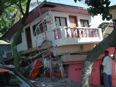
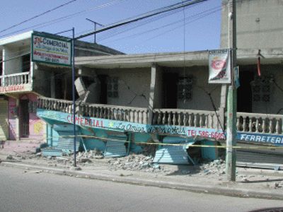
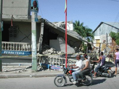
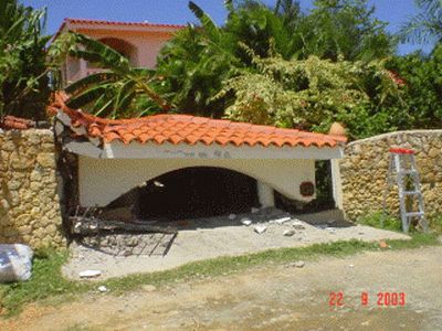
Sept. 22, 2003 Quake
At 11:45 pm on 22 September 2003, a M 6.7 earthquake severely shook the northern part of Dominican Republic. It caused extensive damage to buildings in the major cities of Puerto Plata and Santiago along with landslides in the outlying areas. There were also several large aftershocks (over 200 in all) that happened in the days and hours following this quake.
Here are a few pictures of an earthquake that happened in September 2003. These were taken in the Puerta Plata area by our friend Cochman.
September 2003 Earthquake in Puerta Plata Dominican Republic houseSeptember 2003 Earthquake in Puerta Plata Dominican Republic storeSeptember 2003 Earthquake in Puerta Plata Dominican Republic observing the damageSeptember 2003 Earthquake in Puerta Plata Dominican Republic house
Recommended Emergency Products
The Earthquake Alarm (Amazon) can wake you up and alert you the moment a quake starts giving you more time to take cover.
*Operates off of a 9-volt battery.
*Loud distinctive alarm to wake you up.
*Can detect earthquakes miles away.
*Fully adjustable sensitivity setting. and more..(incluye instrucciones en espanol!)
I have heard many people use a detector and they say they work quite well. I recommend getting one if you live in any Earthquake prone area.
Another product that I read about is The Quake Escape
Ready America 70280 Emergency Kit, 2-Person, 3-Day Backpack. A backpack that keeps supplies at the ready. (Amazon)
*Sustains two people for three days
*Includes food, water, and emergency blankets
*One 33-piece first aid kit
*USGS Earthquakes Hazards Program has all the Earthquakes listed in the world for the last 7 days. The latest in USA and surrounding areas (including Dominican Republic – sometimes called Mona Passage) with an earthquake of Magnitude 2.5 or greater. All other areas of the world are listed when they have a quake with a Magnitude 4.0 or greater.
Hurricane, Cyclone and Tropical Storm Information for Dominican Republic
Hurricanes (Huracán in Spanish) are devastating. Even if it is only a tropical storm it can be destructive. Here we hope to help you get prepared, endure and learn about hurricanes and how to survive them here in the Dominican Republic.
The work hurricane originates from the Tainos, the original occupants of this island of Hispaniola. Jurakan or Juracán, a Taino God, controlled the power of the hurricane. Jurakan controlled the water and winds. When he was angry a hurricane would appear. He was a very angry deity and was not easy to appease, this is why there are so many storms.
The Spanish who came to the island changed the word from Juracán to huracán. The English adapted the word to become the word hurricane that we use today.
Hurricane Season
The hurricane season in the Caribbean begins on June 1st and finishes in November. In Dominican Republic the most active months for a cyclone are usually mid August through September. The island gets a serious brush on average every 5.03 years. It is averaged that we get a direct hit once every 22.66 years.
We have had 22 hurricanes that have impacted the coast from 1871 to 2004 of which 5 were very devastating.
*September 3, 1930: Huracán San Zenón (4,500 (some accounts say more than 8,000) lives lost. This was one of the top five most devastating Caribbean cyclones)
*October 3, 1963: Huracán Flora (400 lives lost)
*September 26, 1966: Huracán Inés (60 lives lost)
*August 31, 1979: Huracán David (1,000+ lives lost)
*September 22, 1988: Huracán Georges (247 lives lost)
The devastating Huracán San Zenón struck Santo Domingo, the Colonial City, on September 3, 1930.
There are a few more pictures of this Hurricane in the Old Pictures Collection – pictures 72,73 and 74)
A hurricane is a type of tropical cyclone, the general term for all circulating weather systems over tropical waters. The hurricane moves counterclockwise in the Northern Hemisphere.
Tropical Disturbance or Tropical Wave is a random mass of thunderstorms, very little if any, organized wind circulation.
Tropical Depression is an organized system of clouds and thunderstorms with a defined circulation and maximum sustained winds of below 39 mph (34 knots) or less.
Tropical Storm is an organized system of strong thunderstorms with a defined circulation and maximum sustained winds of 39 to 73 mph (34-63 knots).
Hurricane is an intense tropical weather system with a well-defined circulation and maximum sustained winds of 74 mph (64 knots) or higher.
The hurricane is categorized from 1 (weakest) to 5 (strongest).
*Category 1 winds measure between 74 and 95 mph..(64-82 knots)
*Category 2 winds measure between 96 and 110 mph (83-95 knots)
*Category 3 winds measure between 111 and 130 mph. (96-113
knots)
*Category 4 sustainable winds between 131 and 155 mph. (114-
135 knots)
*Category 5 Sustainable winds over 155 mph. (135 knots and
above)
Many hurricanes do weaken when and if they hit Dominican Republic because of its rough terrain. If a hurricane or Tropical storm does hit it is very devastating to the coastal areas. Obviously the wind, storm surge and rain are serious issues when we are hit with a hurricane. In the interior of the island heavy rainfall can cause mudslides, destroy mountain roads and homes.
Flooding on Playa Cocolindo after Hurricane Sandy passed Dominican Republic October 2012
WARNINGS
HURRICANE WATCH means there is a possibility that you could experience hurricane conditions within 36 hours.
You need to prepare just to be safe. Secure the boat, make sure you have all the items ready for securing your home and belongings. Better to be safe than sorry.
HURRICANE WARNING means that sustained winds of at least 74 mph are expected within 24 hours or less.
If this warning has been issued people should be actively preparing for the storm. Also deciding the safest location to be during the storm.
The hurricane season in Dominican Republic usually lasts from the beginning of June to the end of November, with August and September being the months of greatest storm activity. The hotels and resorts are usually prepared in case a storm does strike while you are visiting. They will inform their guests what is best and may evacuate you to another place if necessary. In general, the island is prepared for these storms and the tourists are usually well taken care of. If a hurricane has hit and you are planning a vacation here call ahead and make sure all is still ready for your arrival.
Many of the buildings in Dominican Republic are made from blocks, cement, iron rods, sand and gravel. These materials are generally weather-resistant. There are also many buildings and homes with tin roofs. These can become deadly when they become dislodged. Also, watch out for flying coconuts.
A large hurricane named Georges hit Dominican Republic on September 22, 1998. It was a category 3. The one before that was hurricane David in 1979. This was a category 5. Thus, the likelihood of getting caught in a hurricane is very small. But, when a hurricane does strike there is a good chance there will be destruction. The threat of a possible approaching hurricane should always be taken seriously and all necessary precautions should be taken.
The smaller Hurricane Issac as seen from the Malecon, Santo Domingo in front of the Jaragua Hotel August 2012
What To Do In Case Of a Hurricane
If you are not in a major hotel or are living on the island and there is a hurricane threat here are a few things you can do to keep yourself safe. Please be prepared in advance. There are many web sites with complete lists on how to ready in the care of a tropical storm or hurricane. This is a short list of what to do so you can be prepared.
*Know the evacuation routes or know someone that knows the routes.
*Bring in things from the outside that can blow around. Anchor objects that cannot be brought inside.
*Secure windows with shutters, boards or tape.
*Stay inside, away from windows, skylights and glass doors.
*Keep a door or window open on the opposite side of the force of the wind to avoid a build-up of pressure that will suck your roof off.
*Fill up the gasoline tanks of all your vehicles.
*Fill baths and clean containers with water. Only drink water after it has been boiled for at least 5 minutes or after bleach has been added (eight drops/gallon) or use a water purifier.
*Make sure your propane gas tank supply is shut off at the time of the storm.
*Turn off electricity mains.
*Do not light candles or lighters until you are sure there are no escaped gas fumes close by.
*Make sure to have money because banks and ATMs may be temporarily shut down.
*Stay in a room without windows (bathroom, closet) if you are staying in your home.
*Do not use the telephone except for emergencies.
*If the eye of the storm happens to pass over your area, make sure not to venture outside, as the ferocious back end of the hurricane is still to follow. You should also be very careful what you do after a hurricane has passed. People are frequently killed after a hurricane passes due to electric shocks from fallen wires or lacerations.
Emergency Information Pamphlet
Pamphlet put out by the Emergency Center in DR. It is a large file. Please click to open and read (in Spanish). Feel free to save it for reference.
The National Weather Service, National Oceanic and Atmospheric Administration (NOAA) published a Hurricane Safety Guide to help all be prepared in case of a Tropical Storm. It is very complete and informative.
If you live on the island try and have a good plastic tote box filled with necessities just in case the worse happens.
*Food that doesn’t need to be cooked.
*Medicines.
*Basic utensils and can opener.
*Soaps and bathroom supplies.
*First aid supplies.
*Personal information.
*Flashlights, matches, candles and batteries.
*Sleeping gear.
*Camping stove and fuel.
*Clothing and rain gear.
*Some basic tools.
*Water.
*Whatever else you may need to live for a time to make it a bit more comfortable like a book or magazine.
Make sure, if you do decide to leave your home, that you give yourself plenty of time. Do so by heading inland until the storm has passed. If The Dominican Republic Emergency Operations Center / Centro de Operaciones de Emergencias (COE) (checking their web site click on ALERTAS) announces that your area is an evacuation area, it will tell you where the shelters are located and you should go immediately.
Dominican Dog Blog Dogs, Buenagente and Inteliperra, enjoying the rainbow after the storm.
Caring For Pets
Remember you cannot take animals, alcohol, or firearms into a shelter. More information about securing your pet in case of a hurricane on the Dominican Dog Blog “Dog Care For Hurricane Season” (written in English and Spanish).
An amazing view from NOAA Star GOES-East Image Viewer Full Disk View – GeoColor. Here you can zoom into an area nd see some spectacular images of the earth.
A ship at sea as seen from the Malecon, Santo Domingo, during Hurricane Sandy October 26, 2012.
Acqweather, complete information on the weather in Dominican Republic.SPANISH
Mike’s Weather Page, SpaghettiModels.com, has too much information and links to many weather pages. A great resource. He also has pages on FaceBook and Twitter with updated information.
Weathernerds provides weather data in a flexible, practical interface.
Link for information on Hurricane David at Hurricane City (born August 31-died September 4, 1974) hit Dominican Republic September 1, 1979. The storm’s highest wind speed was 174 MPH and was the strongest storm to hit the Dominican Republic since 1930.
Hurricane City has interesting information and a radio program to listen to when there are hurricanes that need reported on.
Legend has it that former President Joaquín Balaguer made a pact with The Virgen de la Altagracia (who is Altagracia?) so the country would not have any large hurricanes…read more on the Myths and Legends page Balaguer and His Hat.
Tropical Storm Jeanne as it passed over Dominican Republic September 16, 2004
Tropical Storm Jeanne
This is a picture of Tropical Storm Jeanne when it briefly reached hurricane strength passing over Dominican Republic on September 16, 2004. This picture was taken at 1:55 p.m. Dominican time while the storm had sustained winds of 120 kilometers per hour (75 mph) with stronger gusts, and was moving west at 11 km/hr (7 mph). Jeanne was down graded to a tropical storm after its encounter with the island of Hispaniola.