Tag Archives: rio ozama

Plaza Monumento a la Caña

Plaza Monumento a la Caña / Sugar Cane Monument Park

The beautiful tree-filled Plaza Monumento a la Caña / Sugar Cane Monument Park is located in Villa Duarte just across the River Ozama from the Colonial Zone. Inside the park are 2 monuments, the Monumento a la Caña/ Sugar Cane Monument and the Monumento Marina de Guerra / Marine Monument.

The beautiful Monumento a la Caña under a spectacular morning sky.

The Plaza | Monumento a la Caña | Monumento Marina de Guerra | Location |

Plaza Monumento a la Caña and the Monumento Marina de Guerra both sit in this tree lined park.

The Plaza

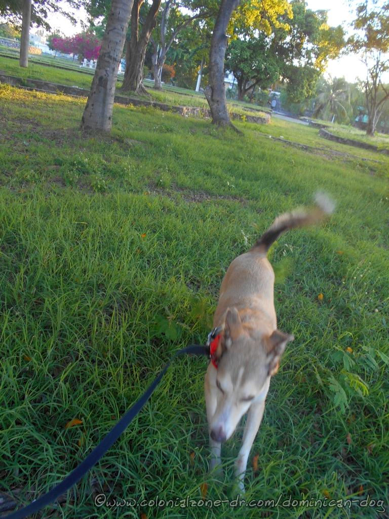
The Parque Monumento a la Caña is a favorite among the locals. You can watch some young people dancing or doing some acrobatic moves. There might be a game of Bittila (similar to baseball but played with a plastic water bottle top). There are usually some local dogs lounging around. And of course, the people enjoying the shade, having a picnic, taking a little snooze or visiting with friends and neighbors. The park is well-maintained by the Santo Domingo Este City Council (SDE).

The charming winding stone staircase leading from Av. Malecon to the Plaza.

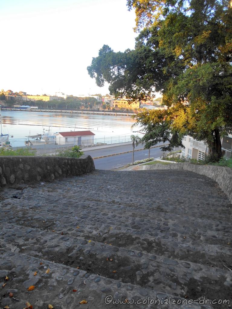
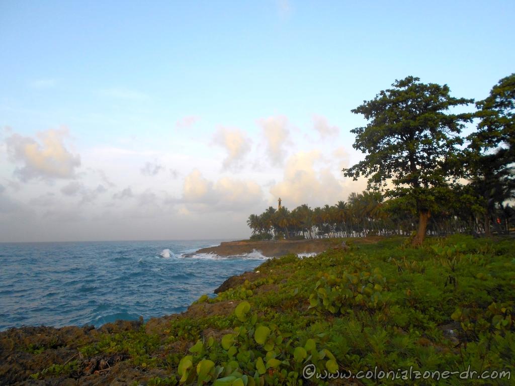
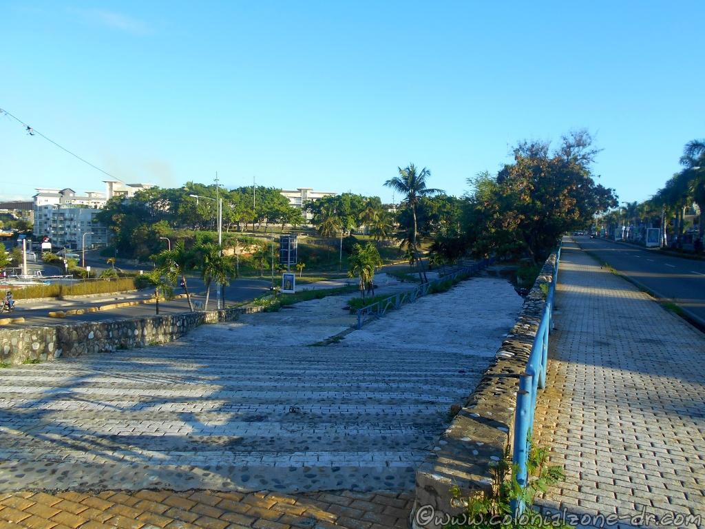
The grande stone staircase is the perfect way to enter the park from the road that runs along Rio Ozama. It is on Av. Malecon across from the Marina Bartolomé Colón where many sail and fishing boats are parked. From the top of these long winding stairs, you can have a beautiful view of the river and the Colonial Zone.

Buenagente is enjoying the cool refreshing grass and shade areas of Parque Monumente de la Caña.

On the other side of the Plaza, separated by a road, is the rest of the Plaza. The road divides this lonely part from the main park. It is a part of the park I call it the Annex. It has 3 levels, one is blocked by a fallen tree, that you can walk. It is not well maintained and is sometimes used as a sleeping spot for street people.

Plaza Monumente de la Caña Annex walkways with Inteliperra sniffing the fallen tree blocking one of the paths.

NOTE: Do not take valuables to this area if you want to walk around. It is not as secured by the police as the Colonial City. It is surrounded by some very poor neighborhoods that are interesting to visit. Also, NEVER GO HERE AFTER DARK. Just to be on the safe side.

Monumento a la Caña / Sugar Cane Monument

A panoramic view of the bronze sculpture Monumento a la Caña in the Plaza.

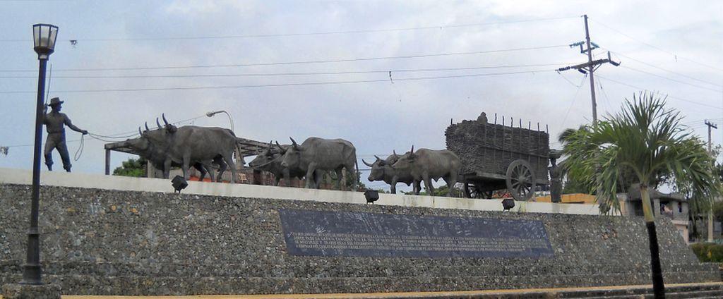
The Sugar Cane Monument consists of a magnificent bronze sculpture that was inaugurated in 1992 by President Dr. Joaquín Balaguer.

The monument dedicated to sugar cane workers under a brightening morning sky.

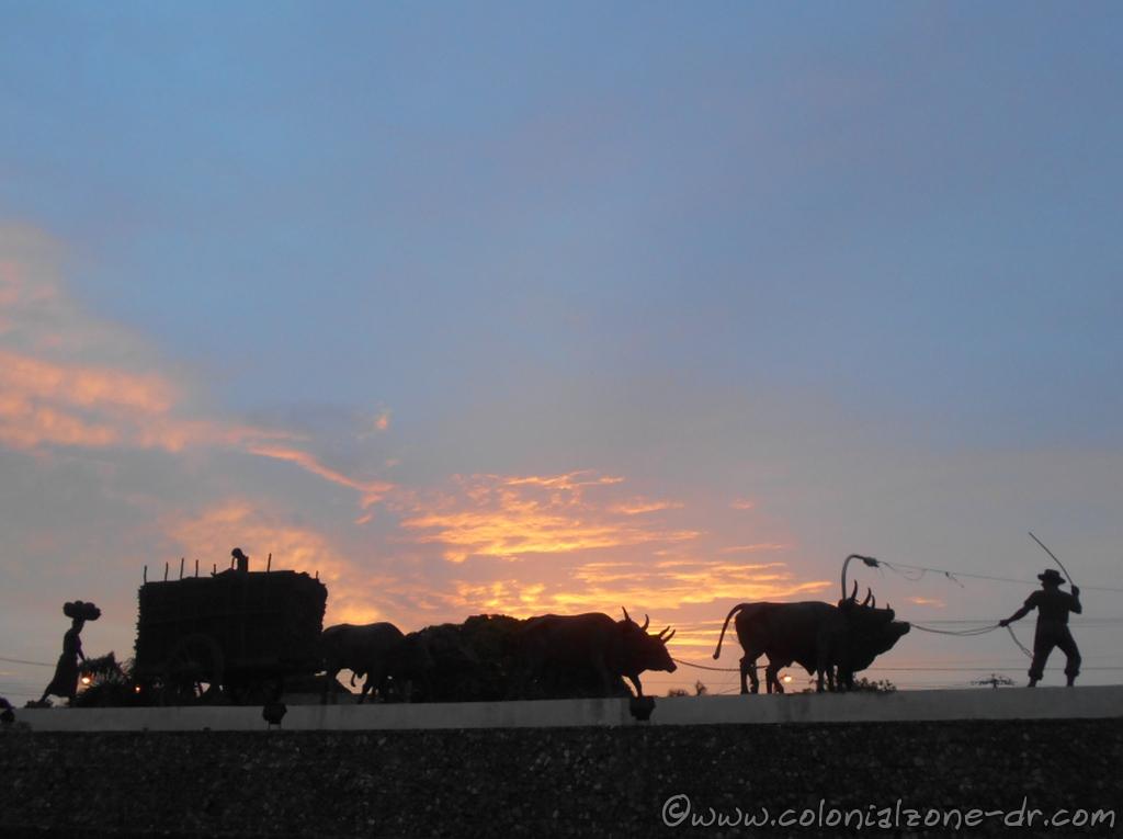
The bronze monument shows six oxen pulling a cart full of sugar cane with a child on top and his mother behind carrying a basket full of Cocoa. The father is the one who guides the animals using a whip. The sculpture depicts the hard work carried out by the colonists, the entire family helping, transporting the raw cane from the field to the mills.

Monumento Marina de Guerra / Marine Monument

Monumento Marina de Guerra is also located in the center of the Plaza Monumento a la Caña

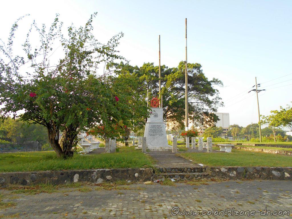
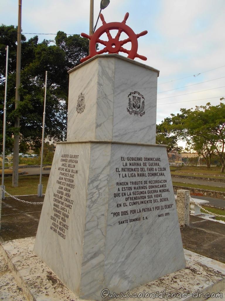
Monumento Marina de Guerra is also located in the center of the Parque Monumento a la Caña. This monument of a ship’s wheel is dedicated to the remembrance of the Dominican sailors who fell during World War 2.

The marble lined monument lists the names of the Dominicans who fell in the war. There is a list of the the Sunken Ships / Naves Hundidas both Steam / Vapor and Schooner / Goleta

The Monumento Marina de Guerra reads:

“El Gobierno Dominicano, La Marina de Guerra, El Patronato Del Faro a Colon, y la Liga Naval Dominicana, rinden tributo de recordación a estos marinos dominicanos que en la segunda guerra mundial ofrendaron sus vidas en el cumplimento del deber. “Por Dios. Por La Patria y Por El Deber” Santo Domingo D.N. Mayo 1999”

(English Translation) “The Dominican Government, the Navy, the Board of Faro a Colon, and the Dominican Naval League, pay tribute of remembrance to these Dominican sailors who in the Second World War offered their lives in the line of duty. “For God. For the Homeland and For Duty ”Santo Domingo D.N. May 1999 ”

The marble lined monument includes the names of those who fell and has a dedication.

NOTE: Do not take valuables to this area if you want to walk around. It is not as secured by police as the Colonial City. It is surrounded by some very poor neighborhoods that are very interesting to visit. Also, NEVER GO HERE AFTER DARK. Just to be on the safe side.

Location

View of the entire Plaza Monumento de la Caña betweeh Av. Malecon and Av. España.

The park is surrounded by Av. Malecon, Calle Maria Trinidad Sanchez and Av. España in Calero, Villa Duarte, Santo Domingo East. It is less than a 10-minute walk from the Puente Flotante/Floating Bridge that connects Santo Domingo to Santo Domingo Este.

Walking from the Colonial Zone cross the Puente Flotante (Floating Bridge). Turn right walking along Rio Ozama. On the left after the large apartment buildings is a staircase that is across from the Marina Bartolomé Colón. You can walk up the stairs and enter the park. If you do not want to go up the steep stairs continue walking to the next road on the left.

Buenagente enjoying the view of the Av. Malecon, Rio Ozama and the Colonial City from atop the stairs of the Plaza Monumento de la Caña.

NOTE: I strongly suggest that if you do not want to climb the stairs that you wait to cross the road. The stone wall after the stairs on that section of the road is not secure. Rocks or the entire wall will fall from time to time.

Faro San Souci Punta Torrecilla

Lighthouse / Faro San Souci at Punta Torrecilla

The Faro San Souci at Punta Torrecilla is located near the entrance to the port of Santo Domingo at Rio Ozama on the South Coast of Dominican Republic. The yellow and black lighthouse stands at the tip of the park Punta Torrecilla on the coral cliffs of the Caribbean Sea. The lighthouse can be seen from many points around the city.

The Faro San Souci at Punta Torrecilla in Santo Domingo sits on the coral cliffs of the Caribbean Sea

The Faro

The original lighthouse in this location was built around 1853. It was deactivated and demolished in 1967. The present Black and Yellow Faro located on the point was built in 1986. It is very similar in appearance to the Survivors Lighthouse on the North Coast in Puerta Plata.

The yellow and black lighthouse on the point at Punta Torrecilla

The pyramid-like concrete tower is 125 feet tall. The entire height, including the light, is 135 feet tall. Faro Sans Souci sends out a blinking white light beacon with a view range of 13 nautical miles. The lighthouse is used as a navigational aid for entrance into the Port of Santo Domingo. The Faro San Souci sits on a terrain about 7 meters above sea level.

Fishermen lining the cliffs at the Punta Torrecilla

Punta Torrecilla Park and Beach

From the vantage point of the park at Punta Torrecilla, there is a beautiful view of the city of Santo Domingo and Avenida George Washington also known as the Malecon. There are usually people fishing off the coral cliffs. Sit, relax and watch the many ships bringing and leaving with their loads. Many Cruise Ships and the Ferry from Puerto Rico come and go from the Puerto Santo Domingo. The ports include Puerto San Souci and Puerto Don Diego.

Broken walkways surrounding the park at the Faro San Souci at Punta Torrecilla

The park was at one time had beautiful walkways along the coral cliffs where the waves of the turquoise Caribbean Sea broke. Now the paths are broken and most lay in rubble. The park is usually littered with trash from people picnicking under the palm trees and there are no facilities.

At the so-called beach local youths like to swim off the cliffs which can be dangerous. Swimming is prohibited here during popular Dominican holidays because of the hazards. It is visited by police and military off and on, trying to keep the area safe. It is OK to visit during the daylight but I would highly advise against visiting after dark. It is a lonely and quiet place where derelicts and bad humans frequent.

The view of the Faro rising above the trees as seen from Avenida España coming from the Airport.

Location

The Park of Punta Torrecilla, where the Faro sits, is located at Dominican Republic’s South East coast in Los Mameyes, Santo Domingo Este along Avenida España on the property of the Naval Base 27 de Febrero. Academia Naval / Naval Academy is located across the street and the Club De Oficiales De La Marina De Guerra / Navy Officers Club is next door. Coming into Santo Domingo from the airport the park sits on the left before you enter the city.

The view of the mouth of Rio Ozama at the Caribbean Sea with the Faro San Souci in the distance. Picture is taken from Playita Montecino at the Malecon in Colonial Zone.

Jacinto de Agua Water Hyacinth

Jacinto de Agua / Water Hyacinth

The Jacinto de Auga is a perennial water plant that is an unwanted invader when outside of its native habitat. This water plant grows rapidly and can be a tremendous nuisance. The thick green plant can obstruct the waterways and prevent light from penetrating the water depleting oxygen for the underwater environments. It is deemed to be one of the worst invasive weeds in the world.

Jacinto de Auga / Water Hyacinth floating on Rio Ozama at the Puente Flotante, Colonial Zone, Dominican Republic

About The Jacinto de Auga | Uses For The Water Hyacinth | Environmental Impact of Jacinto de Auga to the Dominican Republic

Information About The Jacinto de Auga also known as the Water Hyacinth

The free-floating aquatic plant is known as Jacinto de auga, Flor de agua, la Turbia, Camalote, in English is the common water hyacinth. The scientific name is Eichhornia crassipes. Its origin is the Amazon water basin. Now, it is found throughout South America.

The plant is extremely invasive and is exceedingly difficult and maybe impossible to eliminate once it gets ahold. It grows rapidly (it can double in size in just 2 weeks) being one of the fastest growing plants ever. The water hyacinth produces thousands of seeds that can live for over 28 years. The plant rarely attaches itself to the ground. It floats freely with its long roots dangling down from the green plant. The new plants grow off the mother plant through runners or stolons.

The pretty flower of the Jacinto de Auga / Water Hyacinth
The pretty flower of the Jacinto de Auga / Water Hyacinth.

The flower of the water Hyacinth is lovely. It grows on a long stalk. The small flowers are lavender to a pinkish color.

These invasive plants cannot survive in saltwater. Once they work their way down rivers and end up in the sea, they die off.

View of the Colonial Zone with the Jacinto de Auga / Water Hyacinth backed up against the Puente Flotante, Rio Ozama, Dominican Republic

Uses For The Water Hyacinth

There are some positive aspects of the fast-growing Jacinto de Auga. The roots absorb waste and pollutants and convert carbon dioxide to oxygen. They can be made into fuel. The water hyacinth is also excellent for use as compost. More and more uses for the fast growing water plant are being researched and discovered.

The Dirección General de Dragas, Presas y Balizamiento de la Armada de República Dominicana moving the Jacinto de Auga / Water Hyacinth on Rio Ozama at the Puente Flotante, Colonial Zone, Dominican Republic

Environmental Impact of Jacinto de Auga to the Dominican Republic

In the Dominican Republic, the Jacinto de Auga is a nuisance. It obstructs the waterways making it difficult for boats to pass through. After a rain, it breaks loose and works its way down the rivers it has invaded. The green cover makes a good hiding place for some fish species. The issue is that the water hyacinth is also a trash collector. Inside the bright green leaves garbage collects. In Santo Domingo, the plant and the garbage it carries collects behind the Puente Flotante / Floating Bridge.

The Dirección General de Dragas moving the Jacinto de Auga / Water Hyacinth on Rio Ozama out to the Caribbean Sea

The bridge needs to be opened so the Dirección General de Dragas, Presas y Balizamiento de la Armada de República Dominicana (General Directorate of Dredgers, Dams and Lighthouses of the Navy of the Dominican Republic) can push the plants down to the Caribbean Sea where they die from the saltwater. The garbage, plastic and other trash is released to float freely, contaminating the local city beaches. The waste then floats out to sea adding to the giant trash islands in our oceans.

Reference
https://en.wikipedia.org/wiki/Pontederia_crassipes and
http://tropical.theferns.info/viewtropical.php?id=Eichhornia+crassipes